The Blue Ridge Parkway: A Practical Guide to Driving Appalachia’s Scenic Spine
Four hundred and sixty-nine miles of two-lane blacktop that never rushes, connecting two national parks through some of the oldest mountains on the continent. The speed limit is 45 mph for most of the way, and that is the entire point.
There is a particular kind of silence on the Blue Ridge Parkway that you do not find on interstate highways. It is the absence of billboards, exit ramps, and semi trucks in a hurry. For 469 miles the road stays high on the spine of the Appalachians, winding through tunnels of rhododendron, past Civilian Conservation Corps stone walls, and around overlooks where the valleys below disappear into a soft blue haze. The Blue Ridge Parkway is not a shortcut to anywhere. It is a destination built from motion, designed to be driven slowly, ideally with the windows down and a tank of gas you did not wait too long to buy.
This guide covers the full route from the northern terminus at Rockfish Gap, Virginia, to the southern terminus at Cherokee, North Carolina. You can drive it in a long weekend if you are determined, but most people who love the road will tell you that five days is the minimum for anything more than a photographic blur. The parkway is managed by the National Park Service, which means no commercial billboards, no stoplights, and no direct access to towns. You leave and re-enter through designated exits. That design keeps the views uninterrupted, but it also means you need to plan food, fuel, and lodging more carefully than on a typical American road trip.
What the Parkway Actually Is
The Blue Ridge Parkway was conceived during the New Deal as a scenic link between Shenandoah National Park in Virginia and Great Smoky Mountains National Park in North Carolina. Construction started in 1935 and took more than half a century to finish, with the final segment near Grandfather Mountain completed in 1987. The road was never meant to move freight efficiently. It was built to move people through beauty.
Thousands of Civilian Conservation Corps workers shaped the early miles, building stone walls, tunnels, overlooks, and picnic areas by hand. The designers deliberately avoided straight, efficient grades. They wanted the road to follow the contours of the mountains, to hide the approach of a tunnel inside a grove of trees, and to reveal a valley only at the moment a driver rounded a curve. That landscape-first philosophy is why the parkway still feels less like a highway and more like a very long garden path.
Today the parkway receives something close to fifteen million visits a year, though the traffic spreads out so well that most stretches never feel crowded except during peak fall color. The road is free to use. There are no entrance stations, no tolls, and no required permits for driving. Visitor centers, campgrounds, and historic sites line the route, most operated seasonally from spring through late autumn. Winter does not close the entire road, but ice and snow shut individual gates at higher elevations, especially around Waterrock Knob and Grandfather Mountain.
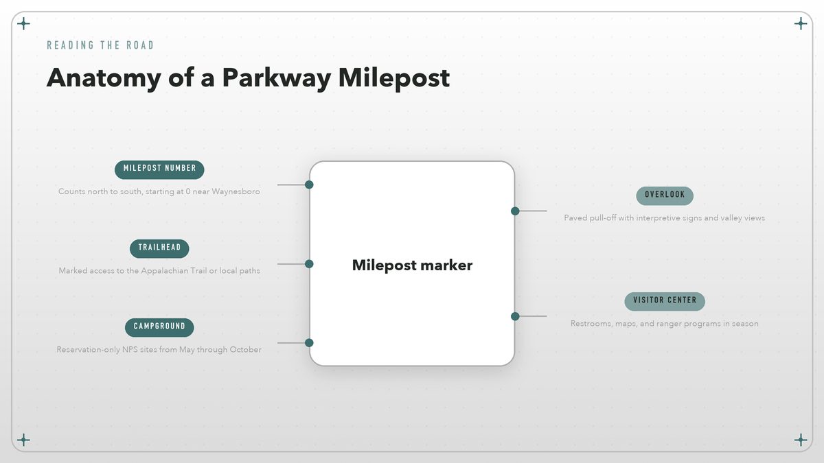
The milepost system is your best friend. Numbers start at zero near Waynesboro, Virginia, and count south to milepost 469 at Cherokee. Every overlook, trailhead, campground, and picnic area is identified by its milepost, which makes navigation almost old-fashioned in the best way. You can plan a day by saying “let’s stop at milepost 217” and know exactly where that is. Paper maps still matter here. Cell service is spotty along long stretches of the ridge, and GPS apps sometimes try to route you off the parkway onto faster but less interesting local roads.
The Route at a Glance
| Region | Mileposts | Character | Gateway town |
|---|---|---|---|
| Northern Virginia | 0–63 | Rolling farmland, Shenandoah views, early tunnels | Waynesboro |
| Roanoke and the New River | 63–217 | Open ridge lines, historic mills, city access | Roanoke |
| Plateau and Piedmont | 217–339 | Waterfalls, granite domes, transition into Carolina highlands | Boone / Blowing Rock |
| Asheville to the Smokies | 339–469 | Highest elevations, craft culture, Cherokee finish | Asheville / Cherokee |
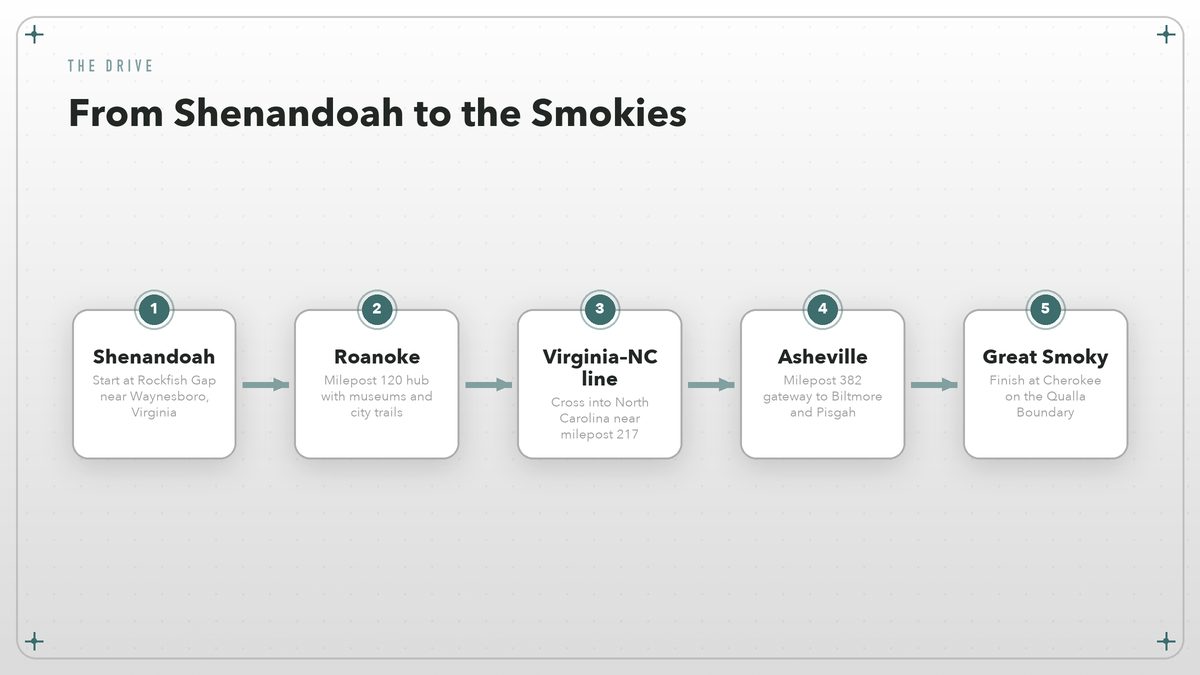
A Five-Day North-to-South Drive
This itinerary assumes you start in Charlottesville or Waynesboro and finish in Cherokee, with overnight stops planned so you spend more time looking at mountains than at hotel signs. You can reverse it without any real penalty. The mileage is low each day because the driving itself is the activity.
Day 1 — Shenandoah to Roanoke
Leave Waynesboro after breakfast and enter the parkway at Rockfish Gap, milepost 0. The first hour is gentle, pastoral, and a good warm-up for the tighter curves farther south. Stop at the James River Visitor Center around milepost 64, where a short trail leads to the historic Kanawha Canal locks. You reach Roanoke by late afternoon with time to walk the downtown market area or ride the Mill Mountain Star if you want a city view before dinner. Stay in Roanoke.
Day 2 — Roanoke to Fancy Gap
The road gets hillier today. Stop at Mabry Mill around milepost 176, one of the most photographed spots on the entire parkway, where a restored gristmill and blacksmith shop demonstrate mountain life. Keep going to Rocky Knob Recreation Area for a short hike, then push on to Fancy Gap or Galax for the night. The day’s driving is only about 120 miles, but the curves will slow you down. That is the idea.
Day 3 — Fancy Gap to Blowing Rock
Cross into North Carolina around milepost 217 and feel the landscape shift. The ridges get sharper, the valleys deeper, and the overlooks more dramatic. Stop at Cumberland Knob, the first recreation area built on the parkway, and at Doughton Park for a walk through open meadows with long views. Blowing Rock is your base tonight. It is touristy, but the Main Street restaurants are a welcome change from parkway picnics.
Day 4 — Blowing Rock to Asheville
This is the most visually intense day. You pass Grandfather Mountain, Linville Falls, and the Craggy Gardens area, where rhododendron tunnels can feel like driving through a green cathedral in June. Plan for short hikes at Linville Falls or Craggy Pinnacle. Asheville offers every kind of lodging and food, so treat this as your restock night. If you have an extra day, save it for Asheville.
Day 5 — Asheville to Cherokee
The final stretch climbs to some of the highest elevations on the route, including Waterrock Knob at milepost 451, where a short trail leads to a 360-degree view. Stop at the Oconaluftee Visitor Center near milepost 469 for a final break before rolling into Cherokee, the southern terminus on the Qualla Boundary of the Eastern Band of Cherokee Indians. From here you can loop back through Great Smoky Mountains National Park or head home.
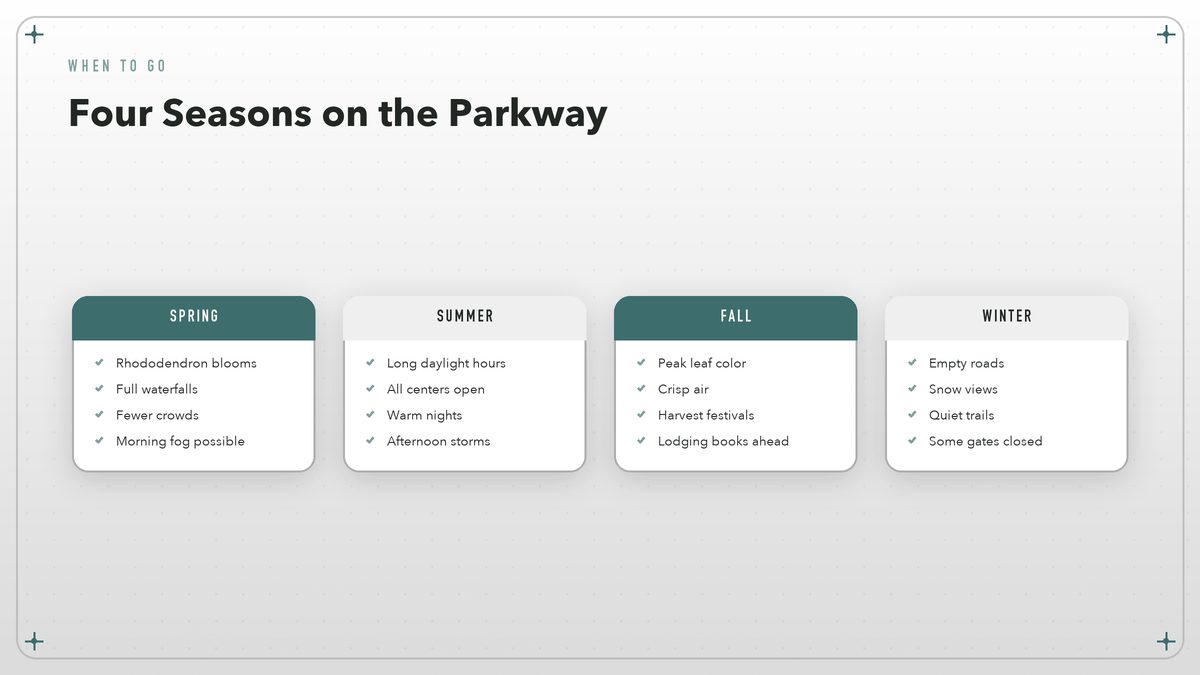
When to Go
October is the month everyone talks about, and for good reason. The sugar maples, sourwoods, and hickories turn the mountains into a rolling quilt of orange, red, and gold. But October is also the busiest month, with leaf-peeper traffic backing up at popular overlooks and lodging prices climbing in Asheville and Boone. If you want fall color without the worst crowds, try the last week of September at higher elevations or the first week of November in the southern stretches.
Spring is underrated. By May, the parkway’s famous rhododendron and mountain laurel begin blooming, and waterfalls that slow to a trickle in August are running full. Fog is more common in spring, which can close some high-elevation overlooks for an hour or two in the morning. I think the mist makes the ridges look older. June is reliably green and warm, with most visitor centers and campgrounds open by Memorial Day.
Summer brings afternoon thunderstorms, especially in July and August. They are usually brief, but lightning on exposed ridges is a real hazard, and wet roads demand extra caution on curves. The benefit is long daylight, warm evenings, and full access to every facility. Winter can be magical if you catch a fresh snow, but it is also the season of closed gates and empty visitor centers. Always check the National Park Service website for current road status before a winter trip.
Where to Stop, Hike, and Look
The parkway is essentially a 469-mile linear park, so the overlooks are the main attraction. Some are small paved pull-offs with room for two cars; others have restrooms, interpretive signs, and short trails. The best strategy is to stop at every other one instead of every single one, or you will never make mileage. Trust your gut. If the light is good and the parking is easy, pull over.
Hiking options range from paved quarter-mile loops to serious mountain trails. Easy highlights include the Craggy Gardens Trail, the Linville Falls overlooks, and the Rough Ridge boardwalk near Grandfather Mountain. Graveyard Fields at milepost 418 is another favorite, a high-elevation flat surrounded by blueberry bushes that turn brilliant red in fall and produce thick berries in late summer. For a longer day, the Appalachian Trail crosses the parkway at multiple points, including a popular stretch near McAfee Knob outside Roanoke. That hike is not on the parkway itself, but the access road is a short detour.
Towns worth exiting for include Roanoke, with its railroad museum and food scene; Floyd, Virginia, for old-time music and mountain culture; Blowing Rock and Boone for a classic Carolina mountain-town feel; and Asheville for breweries, arts, and the Biltmore Estate. Visit North Carolina lists current events and seasonal festivals in the western part of the state, which can help you time a stop around a local fair or music gathering.
Where to Sleep and Eat
There are eight National Park Service campgrounds along the parkway, plus several private campgrounds just off designated exits. NPS campgrounds are reservation-only in season and fill up weeks ahead for summer weekends and October. They range from primitive sites with no hookups to developed loops with flush toilets. None have showers. If you want electricity and hot water, look for private campgrounds in towns like Asheville, Boone, or Fancy Gap.
Lodging inside the parkway corridor is limited. The Pisgah Inn near Asheville and the Peaks of Otter Lodge near Bedford, Virginia, are the two best-known inns directly on the road. Both book up fast. Most travelers stay in gateway towns and drive onto the parkway each morning. That pattern works well because the towns offer restaurants, grocery stores, and laundries that the parkway deliberately lacks.
Food on the parkway itself is minimal. A few visitor centers sell snacks, and the lodges have restaurants, but you should not count on them for every meal. Pack a cooler with sandwich supplies, fruit, and plenty of water. Picnic areas with tables and grills appear frequently along the route, and eating lunch at a roadside table with a valley view is one of the trip’s simplest pleasures. Many overlooks have no trash cans, so bring a bag and pack out everything you pack in. Dinner is the time to exit for a real restaurant in Roanoke, Asheville, or Cherokee.
Driving Tips and Practical Rules
A standard car is all you need. The entire parkway is paved and well-maintained, though frost heaves and fallen branches can create rough patches, especially after winter. Motorcycles are common and often move faster than cars through the curves. Give them room. Cyclists also use the road, and there is no shoulder in most places, so pass only when you have a clear view ahead.
Fuel is the detail that catches first-timers. There are no gas stations on the parkway itself. You must exit at gateway towns to refuel, and the distance between reliable stations can be longer than you expect in the rural stretches. I fill up at every half tank. Carry a paper map or download an offline map, because cell service drops out for long sections, particularly between Roanoke and Asheville.
The National Park Service Parkway maps page lists the official road map and current construction zones, and it is worth bookmarking before a trip. The main National Park Service site is the authoritative source for road closures, facility hours, and campground status. Both update more reliably than crowd-sourced apps.
What to Pack
Weather on the ridge can change fast. A sunny morning at milepost 100 can turn into a foggy, 20-degree-cooler afternoon at milepost 400. Layers are non-negotiable. Bring a rain shell even if the forecast is clear, and pack a warm mid-layer if you are traveling in spring or fall. Good walking shoes matter more than hiking boots for the short trails most parkway visitors actually do.
For the car, bring a physical map, a phone charger, a flashlight, and a small cooler. Sunscreen and sunglasses are useful even on overcast days because the elevation means more ultraviolet exposure than at sea level. Binoculars are nice for hawk watching in fall, and a picnic blanket turns any overlook into a lunch spot. If you are a photographer, a polarizing filter helps cut haze on valley views, and early mornings almost always deliver clearer light than mid-afternoon. Keep your gas tank above half full. It sounds like overkill until you realize the next station is an hour off the road.
The Blue Ridge Parkway is not about arriving. It is about the hours between places, when the trees close in, the valleys fall away, and the road bends just enough to make you curious about what comes next.
Driving the full length of the Blue Ridge Parkway is one of the easiest great American road trips. It requires no special vehicle, no border paperwork, and no advanced outdoor skills. What it asks for is patience and a willingness to move slowly through a landscape that rewards exactly that. Start early, stop often, and let the mileposts mark your progress. Pull over when the light changes. Take the slower curve. The mountains have been here for hundreds of millions of years. They will wait for you to catch up.
Road conditions and facility hours change with the season. Check the National Park Service Blue Ridge Parkway page and the official Parkway maps page for current closures, campground availability, and visitor center schedules before you leave.