Driving Baja California: A Practical Guide to the Tijuana-to-Cabo Road Trip
Mexico’s peninsula is one long invitation to keep the windows down. Here’s how to drive it from border to cape without the guesswork.
There is a moment on Mexican Federal Highway 1, somewhere between the last Pemex station and the next ridge of cardon cactus, when the radio gives up and the cell signal flatlines. The road narrows to a single lane each way, the Sea of Cortez glints through the passenger window, and you realize the only plan that matters is the one written on the dashboard in dust and Post-it notes. That is Baja California — not a place you rush, but a place you drive.
Most visitors to Los Cabos skip the middle. They fly direct from Dallas or Los Angeles, take the shuttle to a resort, and treat the peninsula like a beach with an airport attached. That works fine. But the real Baja — the fish taco stands, the mission churches, the empty Pacific beaches, the dusty valleys where wine grapes somehow grow — only reveals itself at road speed. From Tijuana to Cabo San Lucas is roughly 1,050 miles of two-lane blacktop, enough distance to make you forget the last time you saw a Starbucks.
This guide is for the driver, not the tour-bus passenger. It assumes you want to move at your own pace, make bad decisions about where to stop for lunch, and come home with sand in the floor mats. We will cover the paperwork, the route, the seasons, the fuel strategy, and the small rituals that make a long Baja road trip feel less like an expedition and more like the best kind of wandering.
The Case for Driving the Whole Peninsula
Baja is thin and long, a geographic finger pointing south toward the tropics. Because of that shape, the terrain changes every few hours. Mornings can start in coastal sage scrub near the border, pass through volcanic badlands by lunch, and end among cardon cacti that look borrowed from a desert museum. You do not get that from a direct flight.
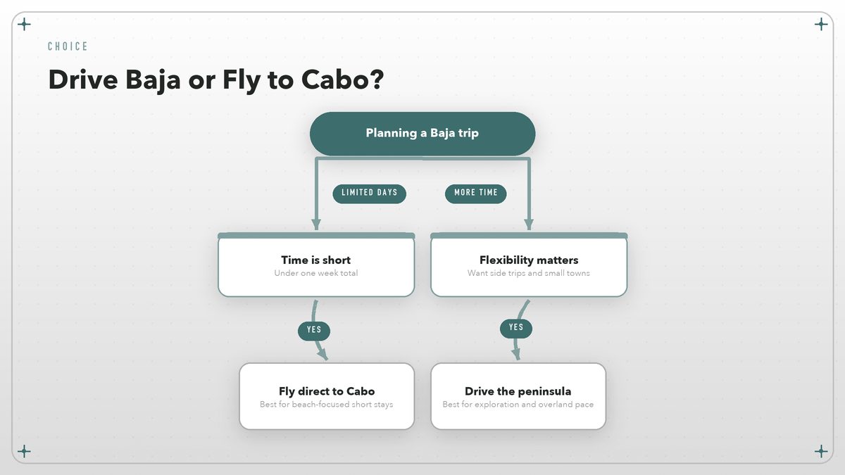
Driving also changes the economics of the trip. A rental car in Cabo can cost more per day than a modest used sedan back home, and the shuttle from the airport to San José del Cabo adds another slice. When you bring your own vehicle, or rent one in Tijuana and drop it in La Paz, the per-mile cost drops fast, and you gain the thing most itineraries pretend does not matter: flexibility. If a village festival is happening in San Ignacio, you can stay; if the wind is wrong for kayaking in Loreto, you can drive inland. You are not anchored to a resort’s schedule.
The trade-off is time. A direct flight from Southern California to Cabo takes under three hours. The drive, without side trips, is two full days of focused driving or four to five days of civilized exploration. Add the wine valley, a detour to Bahía de los Ángeles, or any of the Pacific surf breaks, and you are looking at a week or more. That is not a flaw. That is the point.
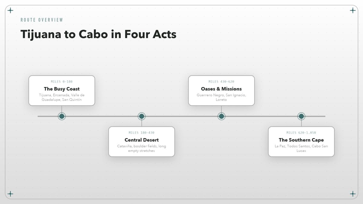
Route at a Glance Mexican Federal Highway 1, border to cape
The route is simple in concept: stay on Mex 1. The highway starts at the Tijuana river crossing and ends at the tip of the cape, with only a handful of significant junctions along the way. Simple, however, does not mean fast. Pavement quality varies, topes (speed bumps) appear without warning in small towns, and livestock has the right of way in practice if not in law.
| Stop | Miles from Tijuana | What to expect |
|---|---|---|
| Ensenada | ~70 | Working port city, seafood tacos, gateway to Valle de Guadalupe |
| Valle de Guadalupe | ~80 | Wine country, farm restaurants, dirt roads after rain |
| San Quintín | ~180 | Oyster farms, bay views, last reliable services for a stretch |
| Cataviña | ~330 | Boulder fields, cave paintings nearby, central desert midpoint |
| Guerrero Negro | ~430 | Gray whale watching town, salt flats, state line |
| San Ignacio | ~500 | Palm oasis, Jesuit mission, lagoon access |
| Loreto | ~620 | Historic mission, islands, sea kayaking base |
| La Paz | ~850 | City services, ferry to mainland, gateway to Cabo |
| Cabo San Lucas | ~1,050 | Tourist hub, marina, dramatic rock formations |
Those mileages are approximate and depend on which side trips you take. The Valle de Guadalupe loop, for example, adds only about twenty miles but can add two hours because the valley roads are unpaved and everyone drives them slowly.
Before You Cross the Border
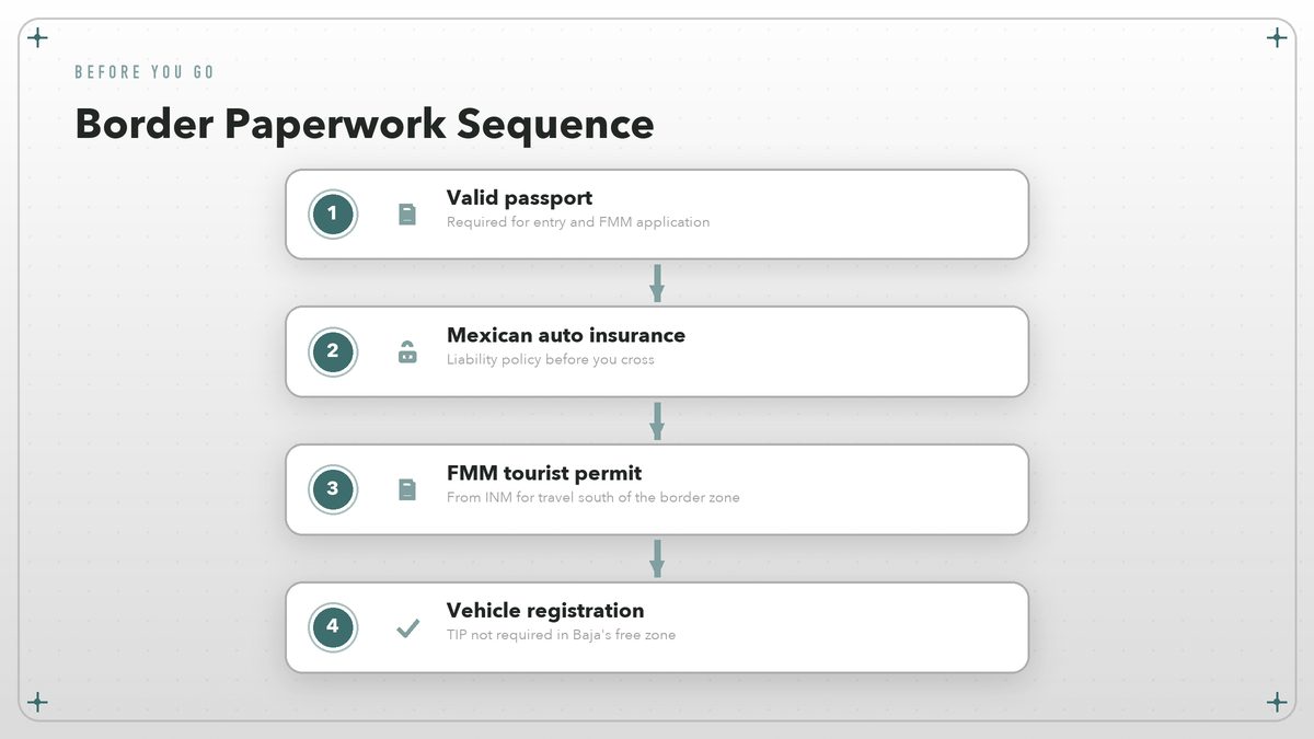
Crossing into Mexico at Tijuana is anticlimactic in the best way. You roll through the port of entry, maybe get a red light at the customs checkpoint, and suddenly the street signs are in Spanish and the speed limits are in kilometers. But the ease of the crossing depends on having the right paperwork sorted before you arrive.
The tourist permit (FMM)
If you are staying in the immediate border zone for less than a week, you can often skip the FMM, the Forma Migratoria Múltiple. The moment you drive south of Ensenada, however, you are outside that zone and you need one. The permit is issued by Mexico’s National Immigration Institute (INM) and is valid for up to 180 days. You can fill it out online before you leave, or stop at the INM office near the Tijuana crossing to get it stamped. Do not lose the stamped portion; you will need it when you exit.
Vehicle permits
Here is the good news: Baja California and Baja California Sur are part of Mexico’s franja fronteriza free zone. That means you do not need a temporary vehicle import permit (TIP) for the entire peninsula, even if you drive all the way to Cabo. Mexico’s National Customs Agency (ANAM) publishes the rules governing temporary vehicle importation, including the free-zone exemption that covers the peninsula. The same exemption does not apply if you put your car on the ferry to mainland Mexico, so keep that distinction clear.
Insurance
Your United States or Canadian auto policy is not valid in Mexico for liability, so you need a Mexican liability policy before you cross. Full-coverage policies are also available and worth considering if you are driving a newer vehicle. Keep the printed policy in the glove box. Mexican law enforcement will ask for it if you are stopped.
Passport and vehicle title
Bring your passport, vehicle registration, and, if the car is financed, a notarized letter from the lienholder authorizing travel into Mexico. If you are renting, confirm the rental contract allows travel on Mex 1 and that the agency provides the registration documents you will need.
The North: Tijuana to Cataviña
The first section is the most forgiving. Cell service is strong, Pemex stations are frequent, and if something goes wrong you are rarely more than an hour from a mechanic who has seen your exact problem before. That makes it a good place to settle into Baja driving rhythms: pass on the left, expect unexpected topes, and never assume the car ahead will signal.
Tijuana itself deserves more than a drive-through. The food scene in Tijuana and nearby Rosarito has outgrown its spring-break reputation; the fish tacos originated here, and the craft breweries along Boulevard Agua Caliente are worth an evening. But most road-trippers push through to Ensenada, about seventy miles south, for the first real stop.
Ensenada is a working port with a tourist-friendly waterfront, and the Mercado Negro is the place for seafood lunches. The nearby Valle de Guadalupe is Mexico’s most interesting wine region. If you have time, spend a night at one of the valley’s smaller posadas and eat at a restaurant that sources from the farm out back. The roads in the valley turn to mud after rain, so a vehicle with some ground clearance helps, though it is not mandatory.
South of Ensenada, the coast empties out. San Quintín is the last town of any size before the long central stretch, and it is famous for oysters pulled from the bay each morning. After San Quintín, the highway turns inland, climbs through volcanic hills, and drops into the boulder fields around Cataviña. This is where Baja starts to feel like Baja: empty, dry, beautiful, and a little unforgiving.
The Central Desert: Cataviña to Guerrero Negro
This is the stretch that separates casual drivers from committed ones. For roughly a hundred miles, services are sparse. You will want a full tank leaving Cataviña, plenty of water, and a sense of humor when the pavement turns wavy from heat and truck traffic.
Cataviña itself is little more than a motel, a restaurant, and a gas station. The surrounding scenery of granite boulders and giant cacti, though, is unforgettable. The nearby cave paintings at Rancho Santa Teresa are among the best preserved in Baja, though reaching them requires a guided hike. If you are passing through, at least stop for a walk among the boulders at sunset; the light turns the stone the color of a blood orange.
Guerrero Negro marks the border between Baja California and Baja California Sur, and it is also the place where gray whales come within arm’s reach of small boats from January through March. The town exists because of a massive salt works, but for travelers it functions as a rest stop and a whale-watching base. If you are timing the trip around marine life, this is where you adjust your schedule.
The central desert is not trying to impress you. It simply removes everything that does not matter. By the time you reach Guerrero Negro, the trip has changed from a drive into a migration.
The South: San Ignacio to Cabo San Lucas
South of Guerrero Negro, the peninsula softens. Palm groves appear. The mission towns look like they have been waiting for you since the eighteenth century. The driving is easier, the distances feel shorter, and the Sea of Cortés becomes a constant companion on your left.
San Ignacio is the highlight of this section. It is a genuine desert oasis, a town built around a spring that keeps a palm grove improbably green. The Misión San Ignacio Kadakaamán is one of the best-preserved Jesuit missions in Baja, and the nearby San Ignacio Lagoon is another major gray whale nursery. Even if whales are not in season, the town is worth a slow morning.
Loreto sits a few hours farther south, and that is where the sea kayaking and island trips begin. The Parque Nacional Marino de Loreto protects islands that are mostly empty. They are also entirely photogenic. If you have a few days, take a panga to Isla Coronado or camp on one of the beaches. If you do not, the malecón at sunset is almost as good.
La Paz is the last real city before the cape. It is also where many travelers pause, regroup, and decide whether Cabo is worth the final push. La Paz has the best municipal infrastructure on the route, the ferry terminal for Mazatlán, and a waterfront malecón that locals actually use. It is a better base for exploring the southern cape than Cabo San Lucas itself, unless you want the marina and the nightlife.
The last leg from La Paz to Cabo San Lucas is the most Americanized part of the drive. Todos Santos is a pleasant arts town with good beaches, and Cabo is Cabo: busy, expensive, dramatic, and impossible to ignore once you round the final headland and see El Arco rising from the sea.
Where to Sleep
Baja accommodates every level of self-sufficiency. In the north, you will find hotels, Airbnbs, and full-service campgrounds. In the central desert, options narrow to small motels, government-run campsites, and wild camping on beaches. In the south, the choices widen again. Prices rise, though, as you approach Los Cabos.
Wild camping is part of the Baja ritual for many overlanders. Countless beaches and pull-offs allow informal overnighting, especially on the Pacific side. The etiquette is simple: arrive late, leave early, pack out everything, and do not build fires where they are not permitted. Apps like iOverlander are useful, but local advice from the last gas station attendant is often more current.
Hotels in small towns range from surprisingly comfortable to barely functional. If you are picky, book ahead in Ensenada, Loreto, La Paz, and Cabo. Everywhere else, showing up in the late afternoon and asking for a room works more often than you would expect.
Road Conditions and the Fuel Question
Mexican Federal Highway 1 is paved for its entire length, but “paved” covers everything from fresh asphalt to patchwork concrete to narrow lanes scalloped by erosion. Some sections are smooth and fast. Others demand your full attention. Topes are the real hazard in towns; they are rarely marked well and can be tall enough to scrape an undercarriage if you hit them at speed.
Vados are another Baja signature. These drainage dips can flood within minutes during rare heavy rains. A foot of moving water is enough to sweep a vehicle off the pavement.
The golden rule of Baja fuel is simple: fill up whenever you can. Do not pass a Pemex with less than half a tank south of Ensenada. Stations can run out of premium. Card readers sometimes fail, so carry enough pesos to pay cash. Most stations are full-serve; attendants will pump for you, and a small tip is appreciated.
Phones, Money, and Language
Telcel has the best coverage on Mex 1, though there are long dead zones in the central desert and mountains. A Mexican prepaid SIM bought in Tijuana or Ensenada is cheap and useful. Many U.S. carriers include Mexico roaming, but the connection can be spotty in exactly the places you want it most.
Cash is still king in rural Baja. Pesos are preferred, though dollars are accepted in many tourist areas at mediocre exchange rates. ATMs are reliable in Ensenada, La Paz, and Cabo; elsewhere, do not count on finding one. Credit cards work at larger hotels and restaurants, but a pocket of small bills will save you repeatedly at taco stands, gas stations, and campgrounds.
Spanish helps but is not mandatory. In the towns that live off tourism, English is common. In the villages between, a few polite phrases and a smile go farther than fluency. Download offline maps before you leave; Google Maps works in much of Baja, but offline backups are insurance against the inevitable dead zones.
When to Go
Baja has two sweet spots: late October through November, and March through April. In those windows, the desert is warm but not punishing, the whales are either arriving or still lingering, and the hurricane season has either ended or not yet begun.
Winter, from December through February, is mild in the south and cool in the north. It is the best time for whale watching but the worst time for camping comfort if you are not prepared for chilly nights. Summer, from May through September, is brutally hot in the central desert and humid around Cabo. It is also when tropical storms can turn dry arroyos into dangerous rivers.
Is Baja Safe?
The safety question comes up in every Baja planning conversation, and it deserves a straight answer. The peninsula is generally safe for tourists, and violent crime against visitors is rare. Government travel advisories, including Canada’s entry for Mexico (travel.gc.ca), list specific states and regions; Baja California and Baja California Sur are typically assessed differently from areas farther inland. Check the current advisory before you go, because conditions change.
Common-sense precautions apply: do not drive at night if you can avoid it, because livestock and unlit vehicles are hazards on rural roads. Do not leave valuables visible in a parked car. Stick to main highways unless you have local knowledge. The U.S. Embassy in Mexico (mx.usembassy.gov) publishes safety updates and contact information for Americans who need assistance.
The bigger risks are mechanical and environmental, not criminal. A flat tire in the desert will ruin your day faster than any criminal issue likely will. Carry a real spare, not a donut, plus a tire repair kit, extra water, and a basic tool set. If you are going far off Mex 1, travel with another vehicle when possible, because a breakdown in a remote arroyo is a problem best shared.
Why the Drive Stays With You
A Baja road trip is not efficient. It is not always comfortable. The showers are sometimes cold, the schedule is theoretical, and at least once you will eat something excellent from a cart whose name you cannot remember. But efficiency is not the goal.
The goal is the long afternoon light. It is the fisherman in San Quintín who tells you where the oysters are best today. It is the realization, somewhere around mile 600, that you have stopped checking the clock. Baja asks you to slow down. If you let it, the peninsula gives you back something rare: the feeling that you got somewhere by paying attention to the miles in between.
So fill the tank and stash some pesos in the glove box. Point the car south. The cape will still be there when you arrive. By then, the drive will have become the reason you came.
Route distances and border procedures in this guide are current as of August 2026. Always verify entry requirements and travel advisories with official sources before departure, since rules change. Internal links connect only to other azamerica.org articles.