Newfoundland and Labrador by Car: A Practical Guide to the Viking Trail and Beyond
The eastern edge of North America is a road-tripper’s puzzle — an island province reached by ferry, where fishing villages, fjords, and a thousand-year-old Norse settlement unfold along two-lane highways. Here is how to plan the drive without missing the point.
Most road trips start when you turn the key. A Newfoundland road trip starts when you board a boat. There is no bridge from the Canadian mainland, and that single fact shapes everything about the journey: the pace, the packing, the itinerary, and the sense that you are crossing into somewhere a little apart from the rest of the continent. The island portion of the province is roughly the size of Virginia, with a highway network that is good but never fast, a coastline that refuses to run in a straight line, and small towns spaced like beads on a string.
This guide assumes you are starting on the island, getting there by car from Nova Scotia on the Marine Atlantic ferry. It covers the western and northern coasts first, then loops east through iceberg country and finishes in St. John’s. You can flip the route if you land at Argentia instead of Port aux Basques, and you can stretch it to two weeks without running out of things to do. The official Newfoundland and Labrador tourism site is a useful companion for the latest seasonal hours and event listings, but the real planning starts with a map and a realistic idea of how long it takes to drive here.
I have met people who tried to “do” Newfoundland in five days. They spent most of it watching the dashboard clock. The island rewards the opposite instinct: fewer miles, more stops, and a willingness to take the long way around a headland because someone at a gas station told you there was a good view. Distances are modest on paper, but narrow roads, moose, ferry waits, and weather all have a vote. If you can give this trip ten days, you will see a reasonable slice of the place without feeling chased.
Why This Trip Feels Different
Newfoundland is not a region you pass through on the way to somewhere else. It is the end of the line, geographically and culturally. The island sits at the mouth of the Gulf of St. Lawrence, battered by the Labrador Current and the North Atlantic, and its settlements were built around cod, timber, and a stubborn refusal to leave. Even today, the population of the entire province is under 550,000, and the capital, St. John’s, is closer to Ireland than it is to Toronto. That isolation shows up in the accents, the music, the food, and the way strangers still wave when you meet on a gravel road.
The landscape does its own talking. On the west coast, Gros Morne National Park contains a section of the Earth’s mantle pushed up aboveground, a long freshwater fjord, and mountains that look like they were airlifted from Iceland. On the northern tip, the Viking Trail leads to L’Anse aux Meadows, the only confirmed Norse settlement in North America and a UNESCO World Heritage Site. Along the east coast, icebergs drift past headlands in late spring, puffins nest on sea stacks, and small wooden houses called “saltboxes” perch on rocky coves. There is no single icon that defines the place, which is exactly why a car works so well.
The ferry is not an obstacle. It is the first chapter of the trip, and it forces you to slow down before the driving even begins.
Getting Your Car to the Island The ferry is the only way with your own vehicle
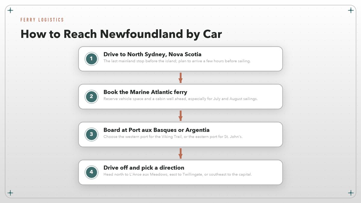
The Marine Atlantic ferry runs year-round from North Sydney, Nova Scotia, to two ports in Newfoundland. The shorter crossing lands at Port aux Basques on the southwest corner after about six to seven hours. The longer, overnight crossing lands at Argentia on the east coast after roughly fourteen hours. Both sailings accept cars, trucks, motorcycles, and RVs, and both can fill up weeks in advance during July and August. Booking early is not a suggestion if you want a cabin or a vehicle spot on a Friday or Saturday in summer.
Port aux Basques is the practical choice for most road trippers because it puts you on the right end of the island for the Viking Trail and Gros Morne. Argentia saves you a long drive if your focus is St. John’s and the Avalon Peninsula, but you pay for that convenience with a longer night at sea. Whichever port you choose, arrive at the terminal at least two hours before departure, have your booking reference ready, and do not expect to find last-minute tickets during holiday weekends. Cabins are worth the cost on the overnight sailing; the day crossing has reclining seats, a cafeteria, and plenty of deck space if the weather cooperates.
Your car needs to be in good shape. Once you leave Port aux Basques, the nearest full-service garage may be a couple of hundred kilometers away, and cell service is patchy along the Trans-Canada Highway between Corner Brook and Deer Lake. Check tires, brakes, and fluids before you board. A spare quart of oil, a physical paper map, and a cooler with snacks are smart additions. The ferry itself has a cafeteria, a small store, and Wi-Fi that works intermittently at best.
Choosing a Ferry Port
The decision between Port aux Basques and Argentia is really a decision about what you want to see first. If you land in the west, you can be in Gros Morne by nightfall and on the Viking Trail within two days. If you land in the east, you are close to St. John’s, the Avalon Peninsula, and the Irish Loop, but you will face a long westward drive if Gros Morne is on your list. Most first-time visitors choose Port aux Basques and work their way east, saving the capital for the end of the trip.
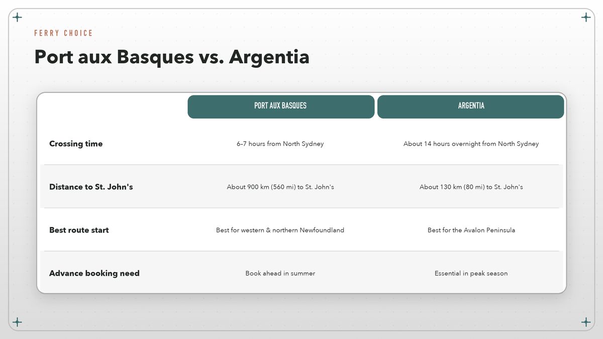
| Factor | Port aux Basques | Argentia |
|---|---|---|
| Crossing time | About 6–7 hours from North Sydney | About 14 hours overnight from North Sydney |
| Distance to St. John’s | About 900 km (560 mi) | About 130 km (80 mi) |
| Best for | Gros Morne, Viking Trail, western coast | Avalon Peninsula, St. John’s, east coast |
| Booking urgency | Reserve ahead in summer | Essential in peak season |
There is no wrong answer. I have taken both, and each has its own rhythm. The Port aux Basques crossing feels like a commuter link with spectacular water views and the occasional whale off the bow. The Argentia crossing feels like a miniature ocean voyage, with passengers settling into cabins, drinking tea in the lounge, and waking up to Newfoundland already outside the window. If you have time, you could even do an open-jaw trip: land at one port and depart from the other.
The Viking Trail and L’Anse aux Meadows
Route 430, better known as the Viking Trail, runs up Newfoundland’s Great Northern Peninsula from Deer Lake to St. Anthony. It is one of the most dramatic drives in eastern Canada, threading between the Long Range Mountains and the Strait of Belle Isle, with views of Quebec’s Labrador coast across the water on clear days. The road is paved and in decent condition, but it is narrow, winding, and often foggy. Moose are a genuine hazard, especially at dawn and dusk, so keep your speed down and your eyes on the shoulders.
The main reason to make the drive is L’Anse aux Meadows National Historic Site, at the peninsula’s northern tip. Around the year 1000, Norse explorers — likely including Leif Erikson’s crew — established a small settlement here, making it the earliest known European presence in the Americas. Parks Canada runs the site with reconstructed sod buildings, costumed interpreters, and a small museum. The place itself is understated: low turf walls, a windswept beach, and a loneliness that makes the Norse achievement feel almost impossible. Give it at least half a day.
On the way up or back, stop at the Tablelands in Gros Morne, the fishing village of Trout River, and the craft shops and cafes that have slowly filled the old outports. The provincial tourism site lists current hours, but the best stops are often unmarked: a roadside bakery, a wharf where someone is selling fresh cod, a trailhead with room for two cars. The Viking Trail is not a road to rush. It is a road to let surprise happen.
Gros Morne National Park: The Fjord That Does Not Look Real
Gros Morne is the kind of park that makes you pull over before you have decided to pull over. The Tablelands, a rust-colored plateau of exposed mantle rock, sits right beside a highway that would not look out of place in the Scottish Highlands. Western Brook Pond, a landlocked fjord carved by glaciers, is accessed by a flat boardwalk and then a boat tour that cuts between thousand-meter cliffs. On a calm day the water is so dark and still it looks like polished stone.
The park is large enough to require two full days if you want to do more than drive through. Good bases include Rocky Harbour, Norris Point, and Woody Point, each with small inns, restaurants, and boat operators. Hiking ranges from short boardwalks to the steep climb up Gros Morne Mountain, which rewards fit walkers with a sweeping view of Bonne Bay and the Long Range Mountains. The official Parks Canada Gros Morne page has trail maps, boat schedules, and current road conditions.
Weather here changes quickly. A clear morning can turn to drizzle by lunch, and fog can roll in off the Gulf of St. Lawrence in minutes. Layered clothing, a rain shell, and sturdy shoes are standard equipment. Do not let mist discourage you — the park has a particular beauty in low cloud, when the fjord walls disappear into gray and the only color comes from the green meadows along the shore.
A 10-Day Newfoundland Road Trip
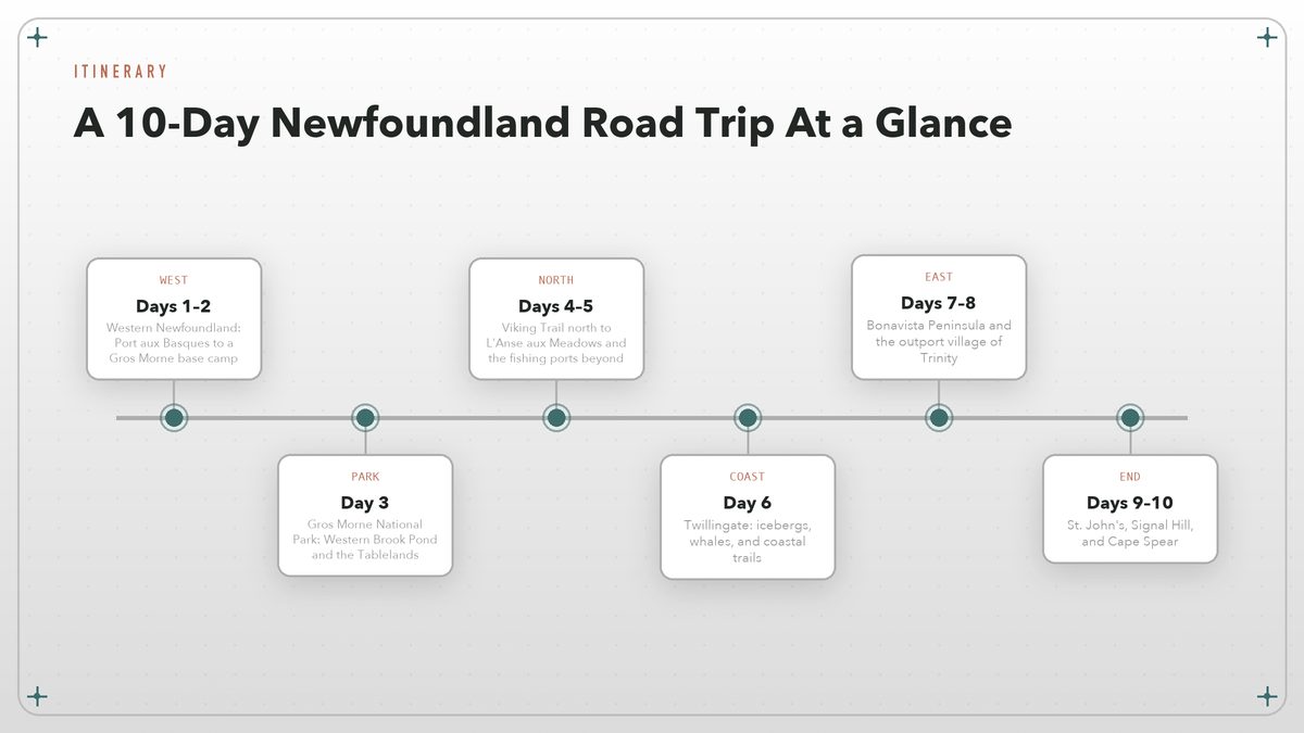
This itinerary lands at Port aux Basques and works eastward, finishing in St. John’s. It balances driving days with full days in one place, which is the only way to enjoy Newfoundland without burning out. Distances look short, but the roads will slow you down.
Day 1 — Port aux Basques to Corner Brook
Drive off the ferry and head northeast on the Trans-Canada Highway. The first hours are a gentle introduction: rocky barrens, small lakes, and the occasional moose-crossing sign. Stop in Stephenville for coffee or a walk along the waterfront, then continue to Corner Brook, the island’s second-largest city and a good place to stock up on supplies and groceries.
Day 2 — Corner Brook to Gros Morne
Continue north toward Deer Lake, then cut west into Gros Morne National Park. Settle into your base camp in Rocky Harbour, Woody Point, or Norris Point, and spend the late afternoon walking the short trail to Lobster Cove Head Lighthouse or exploring the Rocky Harbour waterfront.
Day 3 — Gros Morne National Park
Spend a full day in the park. Take the morning boat tour on Western Brook Pond, then drive to the Tablelands for an easy walk on the exposed mantle rock. In the evening, find dinner in Woody Point or Norris Point and watch the light change over Bonne Bay.
Day 4 — Gros Morne to L’Anse aux Meadows
Head north on the Viking Trail. Stop at the fishing village of Port au Choix for lunch and a look at the archaeological site, then continue to the top of the peninsula. Stay near St. Anthony or at one of the small inns along Route 436.
Day 5 — L’Anse aux Meadows and Cape Norman
Visit L’Anse aux Meadows in the morning, when the site is quietest. In the afternoon, drive the short distance to Cape Norman or the Norstead Viking Village, a living-history site nearby. Return to St. Anthony for the night.
Day 6 — St. Anthony to Twillingate
Retrace your route south to the Trans-Canada, then turn east toward Twillingate, the iceberg capital of Newfoundland. Depending on the season, you may see icebergs drifting in the bay from May through early July. Walk the coastal trails, visit the Twillingate Museum, and have dinner at a restaurant overlooking the water.
Day 7 — Twillingate to Bonavista
Drive south and east to the Bonavista Peninsula. Stop in Terra Nova National Park if you want a forest break, or push straight to Bonavista. The town has a handsome harbor, a replica of John Cabot’s ship, and the famous Bonavista Lighthouse.
Day 8 — Bonavista and Trinity
Spend the morning in Bonavista, then drive the short distance to Trinity, one of the best-preserved historic fishing villages in Newfoundland. Walk the narrow streets, visit the Rising Tide Theatre if there is a performance, and eat somewhere with a view of the water.
Day 9 — Trinity to St. John’s
Make the drive to St. John’s, but do not rush. Stop at Brigus or Cupids, the oldest English settlement in Canada, on the way. Arrive in the capital by late afternoon with time to walk Water Street and find a pub with live music.
Day 10 — St. John’s and Cape Spear
End the trip at Signal Hill, where Marconi received the first transatlantic wireless signal, and Cape Spear, the most easterly point of land in North America. Both are short drives from downtown. If you have an extra day, add a boat tour to Witless Bay to see puffins and whales.
Driving Tips, Weather, and Local Etiquette
A standard car is fine for almost every route in this itinerary. The Trans-Canada Highway and the Viking Trail are paved, though frost heaves and potholes appear after winter. Gravel roads lead to some remote trailheads and outports, but you do not need four-wheel drive for the main attractions. Gas stations are plentiful enough along the Trans-Canada but become scarce on the northern peninsula and in rural parts of the Avalon, so I fill up whenever the tank drops below half.
The province’s 511 Newfoundland and Labrador website tracks road conditions, construction, and ferry delays in real time. It is worth checking before any long driving day, especially in spring when remaining snowbanks can narrow shoulders and in fall when fog can slow traffic along the coast.
Newfoundlanders are famously friendly, and that friendliness extends to driving. Locals will often wave on rural roads, let you merge at ferry terminals, and stop to help if you look lost. Return the favor by pulling over when traffic builds behind you on narrow roads, by not blocking driveways in small fishing villages, and by keeping your voice down at viewpoints where people have come for the silence. In towns, parking is usually free and plentiful.
Seasonal timing matters. June through early September is the most reliable window for weather, facilities, and iceberg or whale sightings. Late September brings fall color and fewer crowds, though some seasonal restaurants and tours close after Thanksgiving. May can be beautiful but cold, with lingering snow in Gros Morne and icebergs still drifting south. Winter is a different trip entirely — quiet, snowy, and limited by road conditions — and it is not what this guide is built for.
Where to Stay and Eat
Accommodation in Newfoundland ranges from national park campgrounds and small motels to restored heritage inns and a handful of boutique hotels in St. John’s. In summer, book ahead. The best places in Gros Morne and Trinity fill up months in advance, and there is not a huge surplus of rooms in small towns. Camping is a good option if you have gear; the provincial and national parks have well-maintained sites, often with unbeatable locations.
Food is one of the trip’s surprises. Cod is still king in rural kitchens, though the fishery has changed dramatically since the 1992 moratorium. You will find fish and chips, toutons — fried bread dough served with molasses — and Jiggs dinner, a boiled salt-beef and vegetable meal that appears on Sunday tables. St. John’s has the widest restaurant selection, including modern takes on local ingredients. Do not miss a proper seafood chowder on a cold day, and try bakeapple berries if you see them on a dessert menu.
The One Thing to Remember
Newfoundland is not a checklist destination. The best moments on this road trip are usually the unplanned ones: a conversation at a gas station, a trail you took because the parking lot was empty, a fogbank lifting over Western Brook Pond just as the boat turned into the fjord. You can plan the route, book the ferries, and reserve the rooms, but the island still gets a say in what happens next. That is the reason to come.
Route distances and ferry schedules change, so confirm details with Marine Atlantic, Parks Canada, and Newfoundland and Labrador Tourism before you leave.