The Alaska Highway: Driving the Last Frontier Road
The ALCAN is not the loneliest road in North America anymore, but the 1,387 miles from Dawson Creek, British Columbia to Delta Junction, Alaska can still feel like one. Drive it right.
The Alaska Highway starts with a humble wooden post in a farmer’s field at Mile 0 in Dawson Creek, British Columbia. From there it runs northwest through spruce forest, muskeg, and three mountain ranges before it finally spits you out at the Richardson Highway junction in Delta Junction, Alaska. Most people call it the ALCAN, short for Alaska-Canada Military Highway. The name comes from 1942, when American Army engineers and Canadian contractors punched the road through wilderness in eight months so supplies could reach Alaska during the war. Today the highway is fully paved, cell service shows up in most towns, and you can buy a latte in Whitehorse. The distance is real, though, the weather can turn ugly fast, and there are still stretches where the next person you see might be a moose. It is still wild.
People arrive at the highway with wildly different vehicles. Motorcycles, vintage VW buses, rental SUVs, and full-size RVs all tackle the same pavement. Badge does not matter. It cares whether the driver has read the conditions, packed a spare, and allowed more time than the GPS suggests. Rushing the ALCAN is the mistake that turns a memorable trip into a slog.
Where the Road Actually Goes
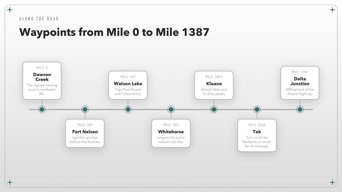
The official length keeps shifting slightly as crews straighten curves and bypass small towns, but figure roughly 1,387 miles (2,232 km) end to end. You leave Dawson Creek on British Columbia Highway 97, cross into Yukon Territory at Historic Mile 627, then enter Alaska near Beaver Creek at Mile 1,221. The whole thing is two lanes, mostly paved, with the occasional gravel patch where construction crews are rebuilding the roadbed. Northern BC Tourism publishes current road-condition links for the province’s northern stretches. Check them before you leave.
Four major river systems cross the route: the Peace, the Liard, the Yukon, and the Tanana. Each one marks a change in geography and a shift in how the road feels. Rivers shape the drive. South of the Liard you are in forested foothills; between the Liard and Whitehorse the mountains close in. West of Whitehorse you enter the big-sky country of the Yukon Plateau and the St. Elias Range, and after the border the Alaska Range dominates the final run into Tok and Delta Junction. The road does not bore you.
Most drivers break it into four or five days. That is not because the speed limit is slow — it is not, outside towns you can often hold 90 to 100 km/h — but because stopping every few hundred miles is the entire point. The towns are small. Speed is not the point. The scenery is enormous, and the daylight in late June can make you forget to sleep. Drivers who try to bash it out in two days often arrive in Fairbanks looking like they’ve been interrogated.
The milepost system is still the language of the road. Older maps refer to “Historic Mile” markers, while newer GPS units track the current road distance, which differs by a few miles. The Milepost guidebook is the standard reference, but the basic chain is simple: Dawson Creek, Fort St. John, Fort Nelson, Watson Lake, Whitehorse, Haines Junction, Destruction Bay, Tok, Delta Junction. If you can remember those nine names, you can navigate the ALCAN in your sleep.
What You’re Driving On
Pavement quality on the Alaska Highway is a rolling lottery. Some miles are perfect. Southern BC from Dawson Creek to Fort Nelson is generally good, though frost heaves appear every spring and the province marks them with little orange flags. North of Fort Nelson the road enters the Northern Rockies and the Liard River valley, where maintenance gets harder and the surface can get choppy. Yukon keeps its section in decent shape. Construction is constant in summer. Alaska’s final stretch from the border to Delta Junction is usually the roughest, with potholes, frost heaves, and the occasional narrow bridge deck. Alaska DOT publishes current construction and condition reports for the state-owned section.
Gravel sections are rare now, but they still happen. Be ready anyway. A mudslide, a forest fire, or a bridge repair can dump you onto a temporary dirt detour without much warning. That is why the rental-car ban exists for most of this route. The major agencies in Edmonton and Calgary will let you take a vehicle to Alaska, but they charge one-way fees that can make your eyes water. Most people either drive their own car or rent an RV in Vancouver or Anchorage and plan a loop.
The worst pavement tends to appear where the permafrost underneath the road is slowly melting, because when the frozen ground thaws, the roadbed sinks and cracks, creating the famous frost heaves. Some are gentle rollers. Others are sharp enough to bottom out a trailer at highway speed. The orange flags help, but only if you are paying attention. When the spacing tightens, lift off the gas.
Your biggest mechanical concern is not boulders. Vibration is. It is the cumulative vibration from 1,300 miles of patched pavement. Check your spare tire before you leave Dawson Creek, and carry two if you are towing. Replace any suspension bushing that is already complaining. Pack a real spare. And do not trust a donut spare on this road; you want a full-size matching spare, because the next tire shop might be 200 miles away.
The ALCAN does not require a monster truck. It requires a car whose owner has already fixed the small problems before they became big ones.
The Season Question
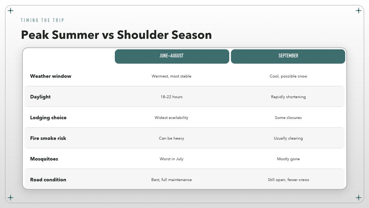
If you have a choice, go in June. June wins. The snow is gone from the high passes, the lodges are open, the wildflowers are out, and the mosquitoes have not yet reached their full horror-movie potential. July and August are also fine, though forest-fire smoke can turn the mountains into silhouettes. September brings fall colors and cheaper lodging, but early snow is possible, and some visitor services close after Labor Day.
Winter driving is a different trip entirely. Do not underestimate it. The highway stays open year-round because it is the only road link between Alaska and the rest of the continent, but daylight is short, temperatures can drop below minus 40, and services are limited. Trucks run the route all winter, which keeps it plowed, but a private car needs winter tires, a working heater, and a willingness to wait out storms. Most tourists should not attempt it outside late May to early October unless they genuinely enjoy adversity.
Planning the Stops
You could drive the Alaska Highway as a straight shot, but that would be like reading the first and last page of a novel. The stops are where the road earns its reputation.
Dawson Creek is the ritual beginning. Start there. There is a visitor center at Mile 0, a signpost where people take the same photo their grandparents took, and enough motels and repair shops to fix the problems you discover on day one. Fort St. John, two hours north, is the last real city for a while. Fill the tank there.
Fort Nelson is where the road starts to feel serious. Wilderness begins. The town sits at the edge of the Northern Rockies and functions as a staging point for the Muskwa-Kechika wilderness. From here to Watson Lake you cross the Stone and Liard ranges, pass the hot springs at Liard River, and enter a stretch of country where black bears routinely graze the road shoulders at dusk. Drive carefully at twilight. Hitting a bison is expensive. It is also sad.
Between Fort Nelson and Watson Lake you also pass Summit Lake, the highest point on the entire highway at just under 4,250 feet. That is not extreme altitude, but the weather can be. Sleet in July is not unheard of. The road climbs through subalpine forest, drops into the Liard River valley, and then hugs the river for long enough that you start measuring distance in beaver dams.
Watson Lake is famous for its Sign Post Forest, a bizarre and oddly moving collection of more than 100,000 homemade signs pointing to hometowns around the world. It started in 1942 when a homesick Army engineer put up a sign for his hometown. Travelers have been adding to it ever since. Add your sign. The town itself is small, but it has fuel, food, and a decent museum.
Whitehorse is the biggest city on the route and the unofficial halfway point. It has breweries, grocery stores, mechanics, and the Yukon River waterfront. Most people take a rest day here. Do the same. West of Whitehorse, the road runs through some of the most dramatic scenery on the entire trip: Kluane National Park, the St. Elias Mountains, and the Kluane Lake viewpoint where the water turns an unreal milky blue from glacial silt. Parks Canada manages the park, and the hiking trails range from flat boardwalks to serious backcountry routes. Travel Yukon lists current park conditions and road alerts for the territory.
Haines Junction sits just outside Kluane and functions as the park’s gateway village, with a gas station, a bakery, and a visitor center where rangers can tell you which trails are open. Destruction Bay, another forty miles west, is smaller but sits right on Kluane Lake and offers one of the great roadside views of the trip. Stop there. Do not rush this section. The mountains deserve your attention.
Beaver Creek, on the Alaska border, is low-key. There is a customs station, a few buildings, and then you are in the final stretch through the Alaska Range to Tok. Tok calls itself the Sled Dog Capital of Alaska and is where most drivers turn north for Fairbanks or south for Anchorage. Delta Junction, 100 miles west, is the official end of the Alaska Highway, marked by a modest sign and a small park where most people pause before continuing on to Fairbanks. The purists stop, take the photo, and call it done.
Vehicle Reality
The Alaska Highway will not destroy a well-maintained modern car. It will, however, expose every maintenance item you have been ignoring. Before leaving, change the oil, check the coolant, inspect the belts, and make sure your battery is not on its last legs. Carry a real spare, a tire iron that fits, a jack you have actually tested, and a basic tool kit.
Fuel range is the calculation that matters. Distance gaps are real. There are gas stations all the way to Alaska, but they can be 100 to 150 miles apart in the remote sections, so when your tank hits half, fill it. That rule removes the anxiety that otherwise haunts the northern stretches. Do not count on premium unleaded. Regular is widely available, but high-octane can be scarce.
A few remote fuel stops are worth knowing by name. Pink Mountain, north of Fort St. John, has a gas station and not much else. Muncho Lake and Liard River Hot Springs sit between Fort Nelson and Watson Lake, and both sell fuel in season. Teslin, on the Yukon side of the Yukon River bridge, is easy to miss if you are not watching the signs. These are not places where you want to arrive with the low-fuel light already glowing.
Towing a trailer is common. RVs and boat trailers are everywhere in summer. Watch the gauges. If you are towing, watch your transmission temperature on the long climbs, carry extra coolant, and remember that grades are steeper than they look. The summit passes are not extreme by Rocky Mountain standards — most are under 4,000 feet — but they are long, and the road surface is not always kind.
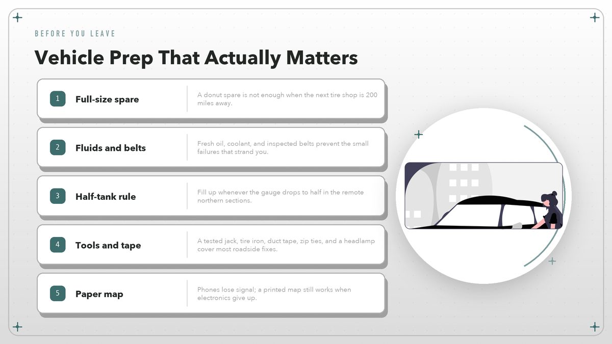
The roadside repair kit for this drive is short and practical: duct tape, zip ties, a tire pressure gauge, a headlamp, and a paper map. Keep it close. GPS works most of the time, but electronics fail, batteries die, and there is something reassuring about a printed map when you are 80 miles from the last town and the phone says “No Service.”
Border Crossings and Paperwork
You enter Canada at one of the western border crossings — most ALCAN drivers come up through Alberta and British Columbia — and you cross back into the United States at Beaver Creek, Yukon / Alcan Border, Alaska. Both crossings are straightforward for US and Canadian citizens with a passport or enhanced driver’s license, though officers can ask about your itinerary, your vehicle, and anything you are bringing into the country. U.S. Customs and Border Protection staffs the Alaska port of entry, and the Canada Border Services Agency runs the Canadian side. Bring your passport.
If you are not a US or Canadian citizen, check visa requirements well in advance. A criminal record, including some old DUI convictions, can make you inadmissible to Canada. Firearms and large amounts of cash require declarations on both sides. If you are bringing a pet, both countries want current rabies vaccination paperwork.
Firearms are a common headache. Know the rules. Canada has strict rules about handguns and certain rifles, and the list of prohibited models changes. If you plan to bring a hunting rifle, register it with Canadian customs when you enter and keep the paperwork visible. The Alaska crossing back into the United States is usually faster. CBP will still ask where you have been, what you bought, and whether you are carrying fruit, vegetables, or firewood that could carry invasive pests.
In practice, the border experience is usually anticlimactic, which is how you want it. Have your documents ready. Answer the questions directly. Do not make jokes about what you might be carrying. The officers on this route have heard every joke twice.
Why It Is Still Worth Doing
The Alaska Highway is no longer an expedition. It is still extraordinary. It is a long, beautiful drive through country that has not been flattened by franchises and billboards. You will see more wildlife in a week than most people see in a year. You will meet people who live in places you cannot imagine living, and you will understand, in a way that no flight can teach, just how big the continent still is.
That said, it is not a road to romanticize. Weather happens. Tires go flat. Bears do not care about your itinerary. The difference between a great trip and a bad one is preparation and patience. Bring a full-size spare, a sense of humor, and more time than you think you need. The highway has been waiting since 1942. It will still be there if you stop for the view.
Verify conditions first. Road conditions change seasonally; verify current pavement, construction, and border status through Alaska DOT, Travel Yukon, Parks Canada, Northern BC Tourism, and U.S. Customs and Border Protection before a trip.