The Pacific Coast Highway: A Practical Guide to Driving California’s Highway 1
California’s Highway 1 is the rare road that matches its reputation. Here’s how to drive it well, from the Golden Gate to the Mexican border.
There is a short stretch of Highway 1 just south of Carmel where the road seems to forget it has a job. It stops hauling traffic and starts threading through cliffs and cypress, hanging over the Pacific like a balcony rail built by someone who trusted the view more than the engineering. That is the moment most people remember. But the Pacific Coast Highway is not one moment. It is 650 miles of moments, some famous and some you will only find because you stopped for gas in the wrong town.
The PCH has been mythologized into something almost too pretty to be real. Postcards sell the curve at McWay Falls and the bridge at Bixby Creek and the red sun dropping behind Malibu, and yes, those places are as good as the photos. But a road trip is not a postcard rack. The real value of Highway 1 is that it forces you to slow down. Landslides close lanes. Fog erases the horizon. Small towns announce themselves with a single traffic light and a better breakfast than you expected. You cannot treat it like Interstate 5.
This guide covers the full run from San Francisco to San Diego, with the practical details that make the difference between a scenic drive and a trip you will actually want to repeat. We will look at the best direction, the seasons, the stretches worth lingering over, the closures that can wreck a plan, and the small habits that keep a long coastal drive from turning into a traffic jam with a view.
What Highway 1 Actually Is
California State Route 1 is a state highway, not a single branded road trip product, though tourism boards often talk about it that way. It runs most of the length of the California coast, from Leggett in Mendocino County down to Dana Point in Orange County, where it ends at Interstate 5. The famous “Pacific Coast Highway” section is generally understood as the part between San Francisco and Los Angeles, but the most dramatic scenery sits between Carmel and San Simeon, in the stretch called Big Sur.
The road is two lanes for most of its length, sometimes narrowing to one lane each way with almost no shoulder. It is not fast. Even on a perfect day, the posted speed through Big Sur hovers around 45 to 55 miles per hour, and you will rarely reach it because every other driver is also looking at the ocean. That slowness is the point. If you need to get from the Bay Area to Los Angeles in a hurry, take Interstate 5 or U.S. 101. Highway 1 is for when the drive is the reason you are going.
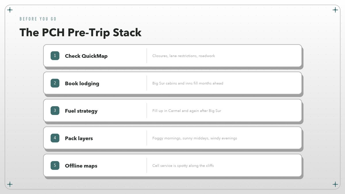
One more thing worth knowing up front: the highway is fragile. Parts of it were carved into unstable coastal slopes, and heavy winter rains can send sections sliding into the Pacific. Caltrans maintains a live road-conditions map called QuickMap that shows closures, lane restrictions, and chain requirements anywhere in the state. Check it before you leave, and check it again the morning you head out.
Route at a Glance San Francisco to San Diego, roughly 650 miles
The full San Francisco to San Diego run is too long for a single day of comfortable sightseeing. Most people break it into three or four days, though you could compress it into two if you are willing to treat it as pure transit. The table below is a rough guide to the major sections and what each one offers.
| Section | Rough miles | What you get |
|---|---|---|
| San Francisco to Santa Cruz | ~75 | Urban exit, coastal farms, surf-town energy |
| Monterey Bay to Big Sur | ~90 | Marine wildlife, cypress forests, dramatic cliffs |
| San Simeon to San Luis Obispo | ~60 | Hearst Castle, elephant seals, wine country nearby |
| Pismo Beach to Santa Barbara | ~80 | Beach towns, Spanish architecture, Channel Islands views |
| Malibu to San Diego | ~165 | Southern California coastline, traffic, classic beach culture |
Those distances assume you stay on or near Highway 1 the whole way. If you detour inland to Paso Robles for wine, or out to Channel Islands National Park from Ventura, add a day. The coast itself is enough to fill a week if you let it.
Which Direction, and When
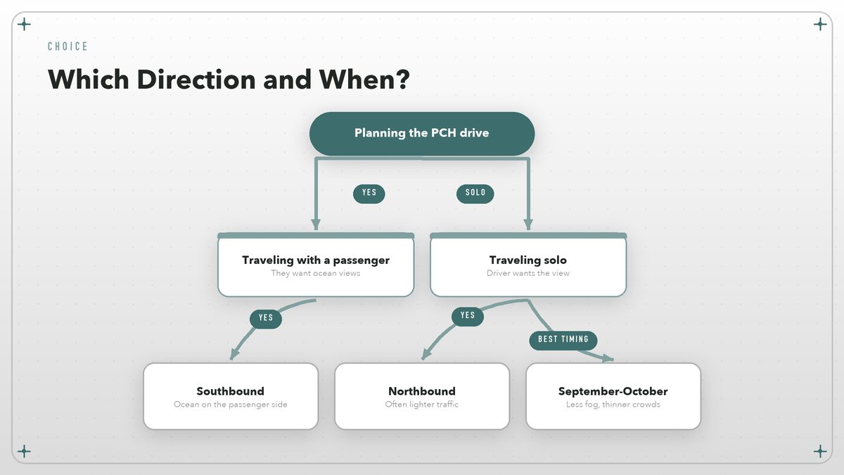
Most guides recommend driving north to south, and for good reason: the passenger side gets the ocean views, which is convenient if you are traveling with someone who wants to photograph the cliffs without leaning across the driver. Southbound also puts the sun behind you for much of the day, which helps during the bright summer afternoons when glare off the water can turn a windshield into a mirror.
That said, northbound has its own case. Traffic is often lighter in the opposite direction, and the views from the driver’s seat are genuinely better if you are alone. I have done the run both ways, and I would pick northbound if I were traveling solo and wanted to feel more connected to the road. Southbound wins for couples or anyone who wants the classic passenger-side panorama.
Timing matters more than direction. June and July are famous for coastal fog along Big Sur, especially in the mornings. The marine layer can swallow the entire coastline until noon, which is a disappointment if you drove six hours for ocean views. September and October are usually the sweet spot: the fog has mostly burned off, the summer crowds have thinned, and the water is still warm enough that the beaches feel usable. Spring is green and wildflower-heavy inland, but it is also when mudslides are most likely to close the road.
San Francisco to Monterey Bay
The northern end of the route is the least dramatic, but skipping it would be a mistake. San Francisco is a natural starting point, and the drive south through Pacifica and Half Moon Bay eases you into the rhythm of the coast. The towns along this stretch are real places, not set pieces. Pacifica has surfers in wetsuits year-round. Half Moon Bay has pumpkin farms and a main street that still feels like 1978.
Santa Cruz is where the energy changes. The boardwalk and the university give it a younger, louder feel than the towns to the north, and the surf culture here is older and less polished than what you will find in Southern California. It is a good place to stop for lunch, walk the wharf, and watch the sea lions argue over dock space. Do not expect a quiet coastal village. Santa Cruz is a city with a beach attached, and that is part of its appeal.
From Santa Cruz, take Highway 1 south through Castroville, the artichoke capital of California, and into Monterey. Monterey is the gateway to the good stuff. The 17-Mile Drive through Pebble Beach is famous, but it is also private and carries an entrance fee. A better use of an hour is the Monterey Bay Coastal Trail, which runs along the water and costs nothing. If you have never seen sea otters in the wild, this is one of the easiest places in the world to fix that.
The Big Sur Stretch
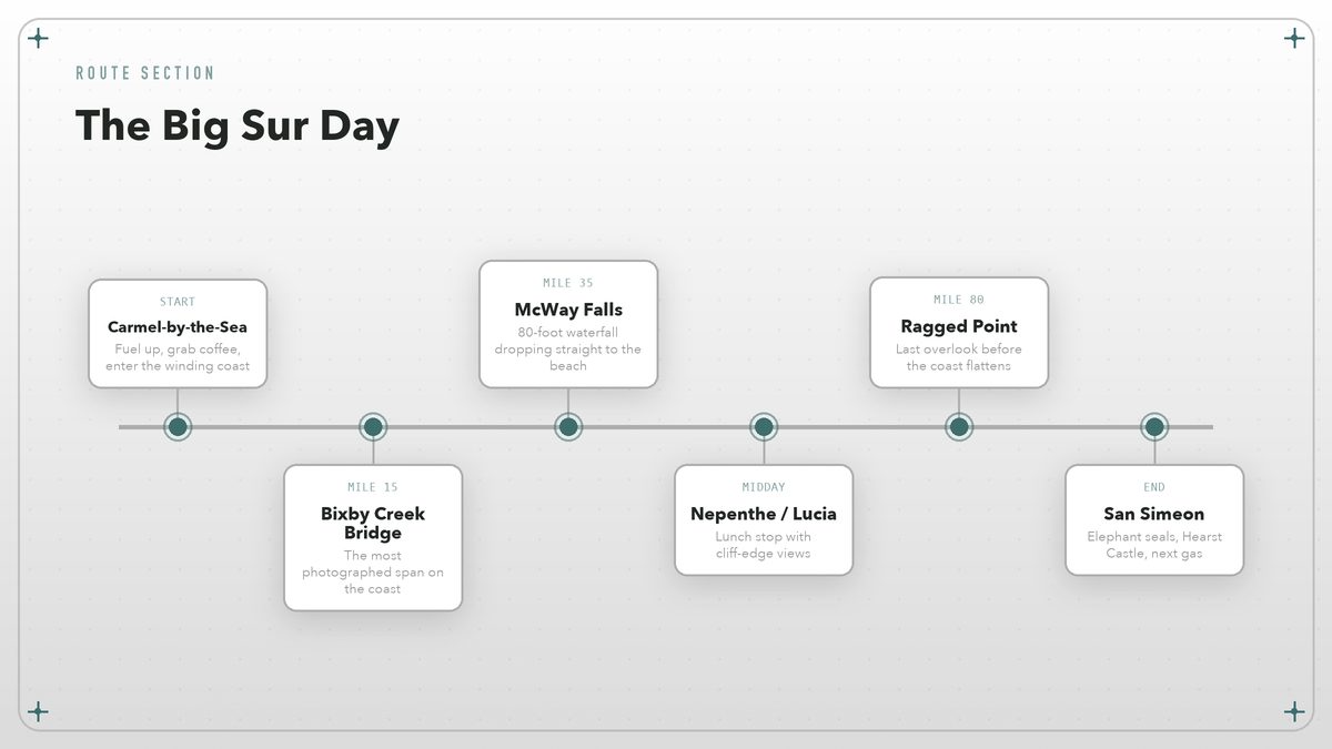
Big Sur is the reason most people come. It is roughly 90 miles of coastline between Carmel and San Simeon, and it contains the highest concentration of postcard views on the entire route. Bixby Creek Bridge, McWay Falls, Pfeiffer Beach, Nepenthe, Julia Pfeiffer Burns State Park — the names pile up fast. What the names do not capture is the feeling of driving through a place that does not want to be convenient.
Cell service is spotty. Gas stations are almost nonexistent — the last reliable fuel before the heart of Big Sur is in Carmel, and the next one is in San Simeon, nearly two hours south depending on traffic. Food and lodging are limited and expensive. That is not an accident. Big Sur has resisted full development for decades, partly because the terrain makes it difficult and partly because the community wants it that way. The result is a stretch of coast that still feels wild, which is rare in a state as populated as California.
Pfeiffer Big Sur State Park is one of the main access points for hiking, camping, and redwood groves just inland from the highway, and its campground reservations run through the federal Recreation.gov system. Further south, Julia Pfeiffer Burns State Park protects McWay Falls, the 80-foot waterfall that drops directly onto the beach. Access to both parks is limited, and parking fills early on weekends, so a dawn arrival is the closest thing to a strategy.
If you only have one day for this section, start early. Traffic builds by mid-morning, especially on weekends, and parking at the popular overlooks fills by 10 a.m. Bring layers. The temperature can swing 30 degrees between a sunny overlook and a foggy cove. And do not plan on rushing through. The road is narrow, the views are constant, and the driver behind you is probably also distracted by the ocean.
San Simeon to Santa Barbara
South of Big Sur, the coast softens. The cliffs lower, the beaches widen, and the highway straightens enough that you can actually look at the scenery without white-knuckling the wheel. San Simeon itself is dominated by Hearst Castle, the estate William Randolph Hearst built on a hill above the ocean. The official Hearst Castle site handles tour reservations, and they are worth booking in advance, especially in summer. Even if you skip the tour, the visitor center and the views from the base of the hill are worth a stop.
Just down the road from the castle turnoff is the elephant seal rookery at Piedras Blancas. The seals haul out here year-round, though the population peaks during breeding season from December through March. There is a free viewing area on the west side of Highway 1, and the animals are usually close enough that you do not need binoculars. It is one of the best wildlife stops on the entire coast, and it costs nothing.
Cambria and Morro Bay are the next two towns worth knowing. Cambria is a quiet village of shops and inns, good for an overnight if you want to break up the drive. Morro Bay has the famous Morro Rock, a volcanic plug that rises from the water at the mouth of the bay, plus a working harbor with fish markets and casual seafood restaurants. From there it is a short drive to San Luis Obispo, a college town with a compact downtown and a weekly farmers market that takes over Higuera Street on Thursday evenings.
Pismo Beach is the next major stop, and it divides opinion. Some people love the wide sand and the classic California beach-town feel. Others find it crowded and overbuilt. I think it is best used as a lunch stop or a place to walk off the car stiffness. Keep going south and you reach Santa Barbara, where the architecture shifts to Spanish Colonial and the climate feels almost Mediterranean. Santa Barbara deserves at least an evening. State Street has restaurants, the Mission is one of the best preserved in California, and the waterfront promenade is a relaxed place to watch the sun go down.
The Southern Stretch: Malibu to San Diego
South of Santa Barbara, Highway 1 joins U.S. 101 for a stretch near Ventura, then splits off again at Oxnard and runs through Malibu. This is where the road enters the Los Angeles orbit, and the character changes completely. The cliffs are still beautiful, but now they are lined with houses worth more than most small towns. Traffic is heavier. Parking is harder. The beaches are prettier from a distance than they are to actually spend a day on.
Malibu is worth driving through slowly. The stretch past Point Dume and Zuma Beach shows off the Southern California fantasy: sun, surf, cliffs, money. But unless you have a specific restaurant reservation or a local friend with beach access, I would not plan to linger. The real action here is watching the drive, not stopping for it.
Santa Monica is the natural next waypoint, with its pier, its promenade, and its famously bad traffic. From there you can stay on the coast through Venice, Manhattan Beach, and Redondo, or cut inland on the freeways if the day is getting long. The beaches of Los Angeles County are more about people-watching than solitude, and that is fine if you know what you are getting into.
Orange County brings another shift. Laguna Beach has art galleries and coves. Dana Point is where Highway 1 officially ends at Interstate 5. From there, Interstate 5 will carry you to San Diego in about an hour if traffic cooperates. If you want a quieter finish, the Channel Islands sit just off the coast near Ventura, and the National Park Service planning page explains the ferry access and day-trip options.
What Can Go Wrong
The most common mistake on the PCH is treating it like a schedule. Landslides, fog, roadwork, and RVs will slow you down. The Caltrans QuickMap site is the best real-time source for closures, but even it cannot predict when a truck will overturn on a tight curve. Build buffer time into every day.
Lodging is the second-biggest challenge, especially in Big Sur. The cabins, inns, and campgrounds book up months in advance for summer and fall weekends. If you are flexible, mid-week travel opens up options. Camping is possible at several state parks along the route, but reservations go fast. The Visit California Central Coast page collects trip-planning resources and regional links that can help with lodging and events.
Fuel is the third concern. On the Big Sur stretch, gas can cost two dollars more per gallon than in Monterey or San Luis Obispo, and stations sometimes run out. Fill up before you leave Carmel and again at the first station you see after Big Sur. The same advice applies, on a smaller scale, to the remote stretches of Mendocino and Sonoma if you are driving the northern extension.
Weather is less predictable than the brochures suggest. Morning fog can hide the coast for hours, especially in summer. Winter storms can close the road. Wildfire smoke from inland fires sometimes drifts west and turns the famous views into a gray haze. There is no perfect season, only a season that matches your tolerance for crowds, fog, and uncertainty.
The Small Rules That Make the Drive
After several runs up and down this coast, the habits that matter are smaller than the scenery. Stop at the overlooks, even the ones that do not have a famous name. Pull over whenever there are five cars behind you. Do not rely on your phone for navigation through Big Sur; download offline maps or carry a paper atlas as backup. Eat breakfast in a diner where the regulars know the waitress.
Pack real layers, not a single hoodie. The coast can be 55 degrees and foggy at 9 a.m., 75 and sunny by noon, and windy by sunset. Sunglasses matter. So does a cooler with water and snacks, because the stretch between Carmel and San Simeon has long gaps with nothing for sale. Keep your gas tank above half full whenever you are north of San Luis Obispo or south of Mendocino.
Finally, give yourself permission to miss things. You cannot see every viewpoint, every beach, every mission, and every seal rookery in one trip. The PCH rewards return visits. I would rather spend an extra hour in one good cove than spend the whole day racing from parking lot to parking lot. The road has been here for decades. It will still be here next year.
External sources: Caltrans QuickMap for road conditions, Recreation.gov for Pfeiffer Big Sur State Park, the official Hearst Castle site, the National Park Service Channel Islands planning page, and Visit California for regional trip planning.