The Utah National Parks Road Trip: A Practical Guide to the Mighty Five
Five national parks, one looping highway, and a week of red-rock scenery that somehow looks bigger in person than in every photo you’ve already seen. The photos lie.
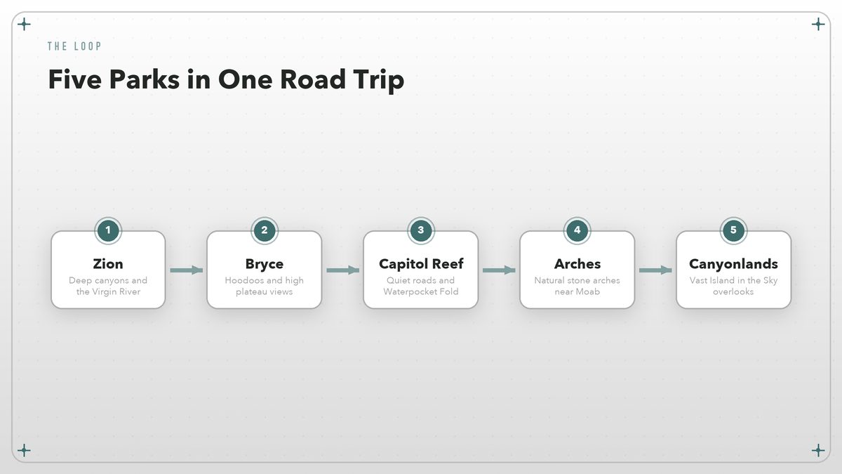
There is a moment on Utah’s desert roads when the GPS still insists you are in the middle of nowhere, but the windshield tells a different story. Mesas rise like stacked pancakes, cliffs glow vermilion in late-afternoon sun, and a sign points toward a canyon you have only seen on postcards. That is the Mighty Five loop in brief: Zion, Bryce Canyon, Capitol Reef, Arches, and Canyonlands, threaded together by paved two-lane highways and a handful of small towns that sell gas, ice cream, and spare sun hats. It feels like nowhere else.
This is not an expedition that demands four-wheel drive or weeks of leave. With a standard car, seven days, and a little planning, you can string all five parks into one coherent road trip. The total loop from Las Vegas back to Las Vegas is roughly 850 miles, which sounds like a lot until you realize most drives are under three hours and every one of them is scenic. The real challenge is pacing: each park deserves at least a full day, and trying to squeeze two into a single afternoon is how you end up watching sunset from a parking lot instead of a rim. So plan accordingly.
What “The Mighty Five” Actually Means
Utah’s five national parks sit in the southern half of the state, spread across about 350 miles from west to east. Zion National Park, the westernmost, is the crowd favorite: a deep canyon carved by the Virgin River, with soaring sandstone walls and trails that range from paved riverside walks to thigh-burning climbs up to Angels Landing. Bryce Canyon, two hours northeast, flips the formula. Instead of looking up at cliffs, you stand on a rim and stare down at thousands of orange hoodoos, those skinny rock spires that look like drip castles left by a giant. The canyon inverts.
Capitol Reef is the quiet one in the middle. It has no single postcard view that dominates social media, which is exactly why it rewards the curious. Waterpocket Fold, a 100-mile warp in the earth’s crust, creates a landscape of domes, cliffs, and narrow canyons without the shuttle lines you’ll find farther west. Then comes Arches, just north of Moab, where more than 2,000 natural stone arches are scattered across a compact park that is easy to explore but hard to photograph without a dozen strangers in the frame. Finally, Canyonlands National Park spreads across three districts; the Island in the Sky district, closest to Moab, delivers the widest views and the most accessible overlooks. The rock changes everything.
Together they form a natural circuit. Most travelers start in Las Vegas because flights are cheap and rental cars are plentiful, then run counterclockwise through Zion, Bryce, Capitol Reef, Arches, and Canyonlands before returning west. You can also begin in Salt Lake City and run clockwise, or fly into Moab’s small airport if you only want the eastern pair. There is no wrong direction, but the counterclockwise loop saves the biggest visual payoff—Canyonlands’ grand vista—for the final morning. I prefer counterclockwise.
The Parks at a Glance
| Park | Signature sight | Best for | Crowd level |
|---|---|---|---|
| Zion | The Narrows, Angels Landing | Slot-canyon hiking and dramatic canyon views | High; reserve shuttles in peak season |
| Bryce Canyon | Amphitheater full of hoodoos | Rim walks and sunrise photography | Moderate; easy to escape on backcountry trails |
| Capitol Reef | Waterpocket Fold, Cathedral Valley | Scenic drives and uncrowded hiking | Low; the most underrated of the five |
| Arches | Delicate Arch, Landscape Arch | Short walks to iconic formations | High; timed entry required seasonally |
| Canyonlands | Island in the Sky overlooks | Panoramic viewpoints and solitude | Moderate; feels vast even when busy |
A Seven-Day Loop That Works
This itinerary assumes you pick up a car in Las Vegas on Day 0, sleep in Springdale that night, and drop the car back a week later. It front-loads the two busiest parks—Zion and Bryce—when your legs are fresh, then eases into the more spread-out eastern parks. Adjust it by a day in either direction depending on how much hiking you actually want to do. Do not rush it. I have seen people try to compress this into five days; they usually remember the rental car more than the canyons.
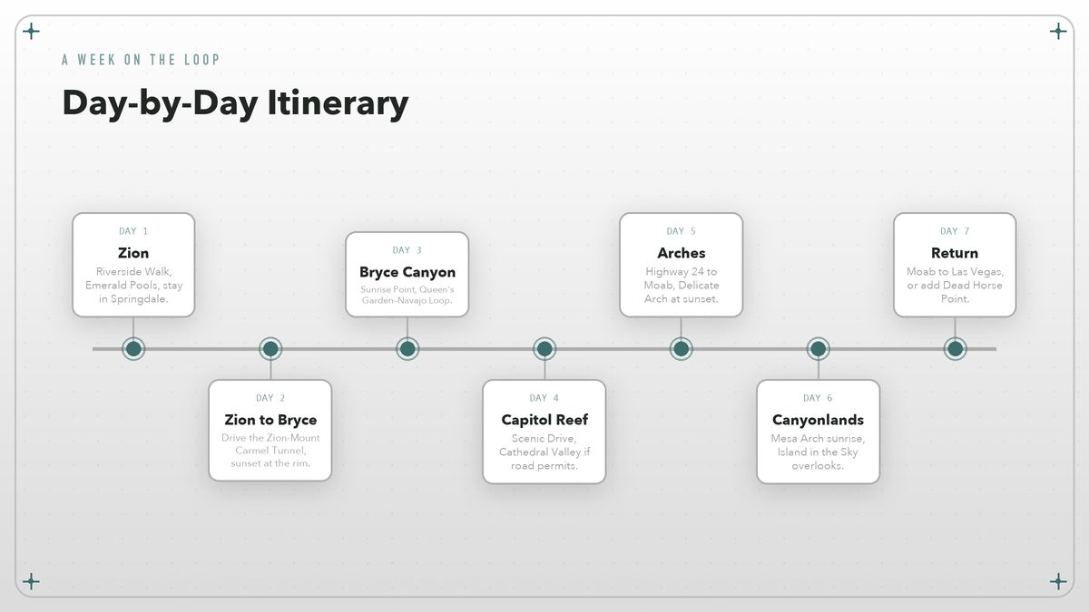
Day 1 — Zion
Ride the park shuttle to the end of Zion Canyon Scenic Drive and walk the Riverside Walk, which is paved, flat, and the gateway to The Narrows if you are willing to wade. In the afternoon, consider the Emerald Pools trails or the lower section of Angels Landing if you secured a permit. Stay in Springdale or at the Zion Lodge inside the park.
Day 2 — Zion to Bryce Canyon
Leave Springdale after breakfast and drive Utah Route 9 east through the Zion-Mount Carmel Tunnel. The tunnel itself is a 1.1-mile blast through sandstone, and the switchbacks on the far side deliver some of the trip’s best unexpected views. Watch for wildlife. You reach Bryce by early afternoon, which leaves time for the Navajo Loop or a rim walk at sunset.
Day 3 — Bryce Canyon
Sunrise at Sunrise Point is worth the alarm. The light is better then. Afterward, hike the Queen’s Garden–Navajo Loop combination, a three-mile figure-eight that drops you among the hoodoos and climbs back to the rim before the afternoon crowds arrive. The rest of the day is for resting your calves, browsing the Bryce Canyon Lodge gift shop, or driving the 18-mile main park road to its highest viewpoints.
Day 4 — Bryce to Capitol Reef
The drive crosses Utah’s high plateau and drops into the small town of Torrey, the gateway to Capitol Reef. Stop at the visitor center first. Then drive the 10-mile Scenic Drive, or the gravel Capitol Reef Gorge Road if your rental agreement allows it. Capitol Reef has no shuttle system, so you can pull over whenever a view grabs you. The views are worth it.
Day 5 — Capitol Reef to Moab and Arches
So start early. Leave Torrey via Highway 24, which threads through a particularly dramatic stretch of the Waterpocket Fold, then climb to Moab over the San Rafael Swell. Aim to reach Arches by mid-afternoon for Delicate Arch at sunset. The trail is three miles round-trip with a steady climb, so bring more water than you think you need.
Day 6 — Canyonlands
Island in the Sky is only 40 minutes from Moab, yet it feels like a different planet. Start at Mesa Arch for sunrise. Then work your way south to Green River Overlook, Buck Canyon Overlook, and Grand View Point. The silence is the point.
Day 7 — Moab to Las Vegas
The direct drive is about 450 miles and takes roughly seven hours, so leave early or break it with a stop in St George. So drive safely. Alternatively, extend the trip by a day and explore Dead Horse Point State Park just outside Canyonlands, where the Colorado River bends in a tight gooseneck 2,000 feet below the rim.
When to Go
Spring and fall are the sweet spots. Plan for crowds. April and May bring wildflowers to Zion’s canyon floor and mild temperatures in Bryce, which sits at 8,000 feet and can still hold snow in late May. September and October offer crisp mornings, reliable sunshine, and the cottonwoods turning gold along the Virgin River. Summer is the busiest season and the hottest, especially in Arches and Canyonlands, where afternoon temperatures can climb past 100°F and shade is basically theoretical. Bring extra water.
Winter is underrated if you don’t mind cold starts. Bryce Canyon becomes a snow-dusted fantasyland, and you can often have the overlooks to yourself. Zion stays relatively mild, though the upper elevations close with snow. Capitol Reef, Arches, and Canyonlands are open year-round, but services shrink and some backcountry roads turn to impassable mud after storms. Check current conditions on each park’s website before you commit to a winter route, because a closed road can turn a quick detour into a very long day. Conditions change fast.
The best month is the one that matches your tolerance for crowds and heat, not the one that looks best on Instagram. Plan for both.
Entry Fees, Passes, and Timed Entry
As of 2026, most Utah national parks charge between $30 and $35 per private vehicle for a seven-day pass, which means a family visiting all five parks could easily spend more on entry fees than on a tank of gas. If you are visiting three or more parks, buy the America the Beautiful annual pass for $80. It covers every national park and federal recreation site in the country for a full year, which means one card gets you into every Mighty Five gate plus any other park you visit that year. It pays for itself here. Passes are sold at entrance stations and online, though the physical card is still the fastest way through a gate.
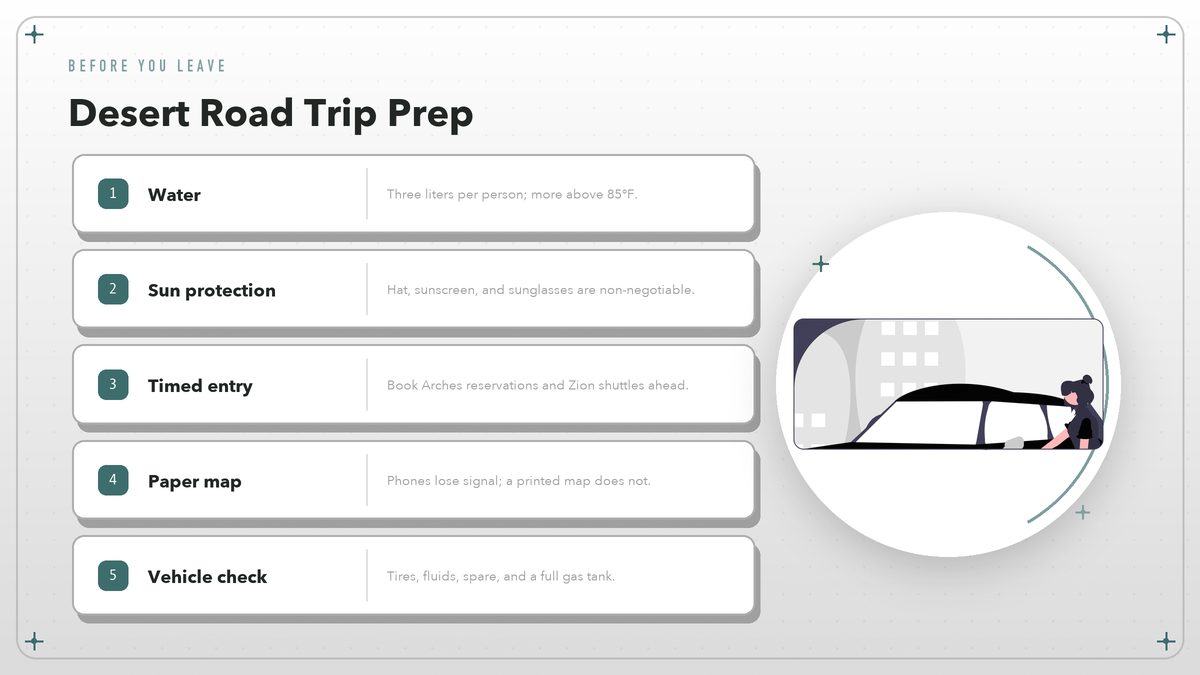
Zion uses a free shuttle through the main canyon for most of the year, which means parking inside the park fills by mid-morning. Springdale runs its own town shuttle that connects to the park pedestrian entrance, so staying in town is often easier than wrestling for a parking spot. Arches requires timed-entry reservations during peak months. Book your one-hour window on Recreation.gov and show the QR code at the gate. The other three parks do not require reservations for private vehicles, though popular trails can still feel crowded by 10 a.m.
Permits are a separate issue. Angels Landing in Zion now requires a permit obtained through a seasonal lottery. Backcountry camping in any of the parks also requires a permit, and spots in Zion’s Narrows and in the Maze district of Canyonlands can fill months ahead. Day hikers do not need permits unless they are entering The Subway or other technical slot canyons.
Where to Sleep
Each park has at least one gateway town with motels, campgrounds, and restaurants, but availability evaporates in spring and fall. Book lodging two to three months ahead for Zion and Bryce. Do the same for Moab. So book early. Capitol Reef is more forgiving, though Torrey has fewer rooms overall.
In-park lodges are the most convenient option where they exist. Zion Lodge sits in the canyon, Bryce Canyon Lodge is a short walk from the rim, and The Lodge at Dead Horse Point sits just outside Canyonlands. None of these are budget options, and rooms sell out within minutes of release dates. Campgrounds are cheaper and often prettier, but reserve through Recreation.gov the moment sites open—typically six months in advance for the most popular loops.
Outside the parks, Springdale has the widest range of Zion-area lodging and restaurants. Bryce is served by Ruby’s Inn and a handful of smaller motels near the entrance. Ruby’s is the biggest. Torrey offers a quieter, ranch-style atmosphere with easy access to Capitol Reef. Moab wins on choice. It is the largest base, with everything from chain hotels to riverside cabins, and it works as a hub for both Arches and Canyonlands.
Driving Between the Parks
The roads are part of the appeal. From Zion to Bryce you climb through ponderosa pine forests and pass the pink cliffs of Red Canyon. Bryce to Capitol Reef crosses the Aquarius Plateau and drops into ranch country. Capitol Reef to Moab includes the Hogback, a stretch of Highway 24 where the road narrows and cliffs rise on both sides, and the Wedge Overlook detour if you have time.
Distances are manageable but deceptive. Springdale to Bryce Canyon is about 85 miles and takes just under two hours. Bryce to Torrey is roughly 120 miles. Torrey to Moab is the longest leg, about 140 miles of winding plateau road that can eat three hours if you stop for photos along the way. Moab back to Las Vegas is a full day. Stop often. Build in time for overlooks, slow RVs, and the occasional cattle crossing.
A standard sedan handles every paved route on this itinerary. Gravel side roads—Capitol Reef’s Cathedral Valley, Canyonlands’ White Rim Road, some Arches back roads—require high clearance and often four-wheel drive. Do not risk it. Rental car contracts generally forbid these surfaces, and a tow out of a remote canyon costs more than the entire trip. If you want to explore dirt roads, rent a proper 4×4 in Moab for a day.
What to Pack and How to Prepare
Desert travel punishes unprepared hikers harder than almost any other environment. The sun is relentless, water is scarce, and the elevation changes mean you can be comfortable at noon and shivering by sunset, sometimes within the same afternoon. The basics are not exotic. But they need to be in your bag every time you leave the car.
Start with water: carry at least three liters per person for any trail longer than two miles, and more if temperatures are above 85°F. Food, sunscreen, a wide-brimmed hat, and sturdy trail shoes with ankle support round out the personal kit. The hat matters. In Zion, you may be walking in the Virgin River, so pack a walking stick or rent one in Springdale; the rocks are slick and the current is stronger than it looks.
For the car, keep a paper map, a phone charger, a basic first-aid kit, and a gallon of extra water. Cell service is spotty between parks. GPS apps sometimes suggest shortcuts that are actually unpaved forest roads. A physical map of Utah or the specific park maps sold at visitor centers will keep you on asphalt. Paper still wins.
A Few Ground Rules
Leave No Trace is not just a slogan in these parks; it is the only reason the trails stay usable with millions of visitors each year. Stay on marked paths, pack out every scrap of trash, and do not stack rocks or carve initials into sandstone. The desert crust that looks like dry dirt is actually a living layer of cyanobacteria, moss, and lichen. One footprint can destroy decades of growth.
Wildlife encounters are usually harmless if you give animals space. Desert bighorn sheep in Zion, mule deer in Capitol Reef, and the occasional black bear in Bryce all lose their fear of people when fed. Keep food in your car, not your tent, and maintain at least 100 feet from large mammals. Snakes are rare on busy trails but common in rocky areas; watch where you put your hands.
Finally, respect the weather. Flash floods can turn slot canyons into death traps within minutes, and summer lightning makes exposed ridges dangerous after lunch. Check forecasts, heed closure signs, and turn back if a canyon starts to look or sound different. Turn back early. The rocks have been here for millions of years; they will still be there tomorrow.
The Mighty Five loop is one of those trips that sounds like a checklist until you are actually standing on the rim of Bryce Canyon at sunrise or watching the last light leave Delicate Arch. It does not require extreme fitness, a specialized vehicle, or a massive budget, but it does reward the traveler who slows down. So slow down. Pick two or three hikes you really want to do, leave room for the drives and the overlooks, and let the desert do the rest.
Park links and fees current as of August 2026. Always check Zion, Bryce Canyon, Capitol Reef, Arches, and Canyonlands for the latest conditions, timed-entry rules, and permit requirements before you leave.