The Oregon Coast by Car: A Practical Guide to Highway 101
There is no single view that defines the Oregon Coast. It is 363 miles of salt air, fog, sea stacks, and small harbor towns threaded together by one two-lane highway.
Most people start with a photograph. Haystack Rock at sunset, perhaps, or the Heceta Head Lighthouse rising above a cliff of green. Those images are real, but they are also traps. They make the Oregon Coast look like a place you arrive at, take in, and leave. In practice, the coast works best as a rhythm you move through, one headland and tide pool at a time. The road itself, U.S. Highway 101, is the organizing idea. It runs the length of the state, sometimes pressed against the beach, sometimes climbing inland through spruce forest, always returning to the water just when you think you have lost it.
Driving it end to end, from the mouth of the Columbia River to the California border, takes about eight hours in theory. No one should do it in eight hours. The entire point is to stop. A heron standing in a slough, a pullout with a view of a sea stack you have never heard of, a diner in a town of 400 people serving clam chowder from a recipe older than most restaurants in Portland: these interruptions are the trip.
This guide is for independent travelers who want to plan their own run. It assumes you have a car, a few days, and no interest in being herded onto a bus. It covers the three distinct stretches of coast, when to go, where to sleep, what to eat, and the small practical details that make the difference between a scenic drive and a trip you remember.
The Road Is the Destination Why Highway 101 matters
U.S. Highway 101 is not an interstate. It is a two-lane road for most of its Oregon length, with occasional three-lane climbing lanes tucked in behind slow RVs. That is the first thing to accept. You will not make fast time. You will, however, see the landscape change in real time. At the north end, the Columbia River meets the Pacific in a wide, brown collision of current and tide. By the time you reach Brookings, near California, the cliffs have turned to red sandstone and the forests are full of Coast redwoods creeping north from the state line.
The Federal Highway Administration tracks the country’s officially designated scenic byways, including stretches of Highway 101, which is a bureaucratic way of confirming that the route is maintained as a corridor of views. You can see Oregon’s entries on the FHWA Oregon byways page. The byway status does not change much on the ground, but it is useful confirmation that the route is maintained as a corridor of views rather than merely a commuter road.
One practical consequence of this is that cell service is patchy. There are long stretches, especially in the southern half, where you will have no bars at all. Download offline maps before you leave. Do not rely on streaming music unless you enjoy silence. The silence, honestly, is part of the appeal.
Fuel is another consideration. Gas stations exist in every coastal town, but the distance between reliable ones grows as you move south. Fill up in Coos Bay or North Bend before pushing into the Bandon-to-Brookings stretch. There is no reason to panic, but there is every reason to avoid the small, old pump with a handwritten sign and prices from another decade.
Three Coasts in One State Northern, central, and southern
Divide the drive into thirds and the trip becomes easier to plan. The northern coast, from Astoria to Lincoln City, is the most visited. Cannon Beach, Seaside, and Manzanita sit here, along with the dramatic sea stacks around Ecola State Park. This is the section people picture when they think of the Oregon Coast: tidy towns, art galleries, espresso, and families on the sand.
The central coast, from Lincoln City down to Reedsport, holds the working harbors. Newport is the largest town on the entire coast, home to the Oregon Coast Aquarium and the Hatfield Marine Science Center. Florence sits at the mouth of the Siuslaw River and is the gateway to the Oregon Dunes National Recreation Area, a federal recreation area where you can hike, camp, and ride off-highway vehicles. Details and permits are available on Recreation.gov. This is the stretch where tourism and fishing still share the same docks.
The southern coast, from Reedsport to Brookings, is the emptiest and, in my view, the most interesting. Bandon has sea stacks that look like a fantasy map. Port Orford is the only town in the lower forty-eight with a commercial fishing dock perched on an open-ocean breakwater. The Samuel H. Boardman State Scenic Corridor, between Gold Beach and Brookings, is a chain of headlands and coves that feels like Big Sur without the traffic.
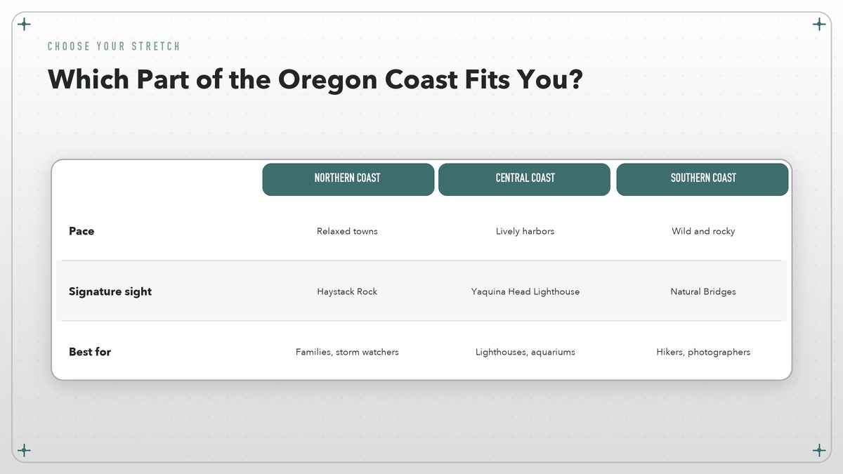
Each third could absorb a full vacation. If you have only three or four days, choose one and slow down. If you have a week, run the whole highway and let the changes accumulate. The northern coast will feel almost suburban after the wildness of the south. That contrast is the trip.
When to Go Weather, crowds, and winter light
Summer is the obvious answer, but it is not the only answer. July and August bring the driest weather and the warmest afternoons, with temperatures rarely climbing out of the sixties. The coast is never hot. That is the point. Portlanders flee inland heat for the marine layer, which is a polite term for fog that can hang around until noon.
Summer also brings the most visitors. Hotels book up, restaurant waits stretch, and the pullouts fill with rental cars. If your schedule is flexible, late June and early September offer nearly the same weather with noticeably fewer people. May can be glorious, with wildflowers on the headlands and enough gaps between rain showers to feel lucky.
Winter is underrated. Yes, it rains. It rains a lot. But winter storms turn the coast into something theatrical. Waves crash over the sea walls in Depoe Bay. The wind bends the shore pines. Hotels drop their prices, and you can walk on beaches that feel private. The Oregon State Parks system maintains year-round access to most coastal parks, and you can check current conditions and closures on the Oregon State Parks website.
Spring is the raw season. Flowers appear, but so do muddy trails and unpredictable skies. Fall is my personal favorite. The light slants lower, the summer crowds have gone home, and the salt air carries the smell of decaying leaves and distant wood smoke.
Where to Stop Towns, parks, and viewpoints worth the time
Cannon Beach is the gateway. Haystack Rock dominates the shoreline, and at low tide the tide pools at its base are full of anemones and sea stars. Ecola State Park, just north of town, gives you the classic viewpoint: sea stacks, surf, and a road winding down through forest. Get there early. By ten in the morning, the parking lot is full.
Lincoln City is less charming but more practical. It stretches for seven miles along the highway and has the usual grocery stores, laundromats, and motels. It is a good place to resupply. It is not a good place to look for character.
Newport splits the difference. The historic bayfront has working fishing boats, sea lions lounging on the docks, and the kind of seafood counters where you can eat clam chowder from a bread bowl while watching the hulls bang against the pilings. The Oregon Coast Aquarium is here, and it is worth half a day if the weather turns.
Florence is the southern gateway to the dunes. The Oregon Dunes National Recreation Area covers forty miles of coast, and the landscape is unlike anything else on the route. You can hike, rent an ATV, or simply stand on a ridge of sand and watch the wind erase your footprints. Just south of town, the Heceta Head Lighthouse sits on a cliff above a small cove. The keeper’s house is now a bed-and-breakfast, and the lighthouse itself is one of the most photographed on the West Coast.
Bandon is where the coast starts to feel remote. The sea stacks off Face Rock State Scenic Viewpoint look like the ruins of a stone city. At low tide, you can walk among them. The town itself has a compact old downtown with a cheese shop, a couple of breweries, and a strong sense that it does not particularly care whether you visit.
Port Orford is smaller still. Its fishing dock is a wooden pier perched on a rock in the open ocean; a crane lifts boats in and out of the water. It is a working harbor, not a tourist set piece. Further south, the Samuel H. Boardman State Scenic Corridor offers a string of viewpoints and short trails. Natural Bridges, Arch Rock, and Thunder Rock Cove are the names you will see on signs. Stop at all of them.
Brookings, at the California border, is the unofficial end of the Oregon Coast. It is also, bizarrely, one of the warmest spots on the coast because of a local microclimate. The azaleas bloom early. The harbor is calm. From here, you can cut inland on U.S. 199 through the Redwoods, or cross into California and keep driving.
Planning the Trip A simple framework before you leave
Start with the car. You do not need four-wheel drive for Highway 101. A regular sedan is fine. You do need windshield wipers that work and enough trunk space for layers. The coast can shift from sunny to sideways rain in an hour, and the temperature can drop twenty degrees when the fog rolls in.
Book lodging early if you are traveling in July or August. The best small inns and state park yurts fill months ahead. Shoulder season is more forgiving, and winter is a buyer’s market. Campgrounds are plentiful, but many coastal state park campgrounds fill on summer weekends. Reserve through the Oregon State Parks system.
Build your days around the tides. Low tide exposes tide pools at Haystack Rock, Cape Kiwanda, and many other spots. High tide can make some beaches disappear entirely. The National Park Service tide tables at Lewis and Clark National Historical Park are one reliable source, but local visitor centers and harbor masters also post daily tide charts.
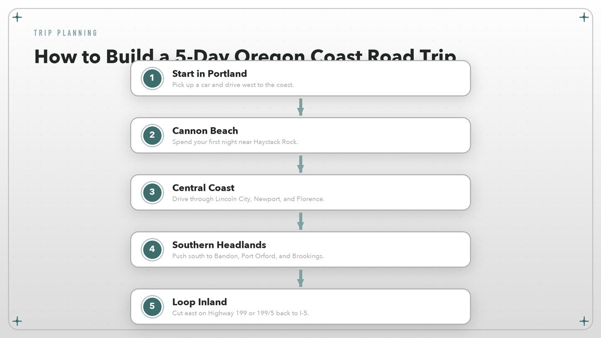
Give yourself permission to change plans. The coast rewards improvisation. A sign for a viewpoint you had not noticed, a recommendation from a campground host, a closure due to a landslide: any of these can reroute a day into something better than what you mapped out.
A Sample Five-Day Itinerary From Portland to the California border
This itinerary assumes you start in Portland and want to see the full length of the coast. It is not the only way to do it, but it is a sensible way. Distances are short, but driving times are longer than the map suggests because of the road’s curves and the certainty that you will stop.
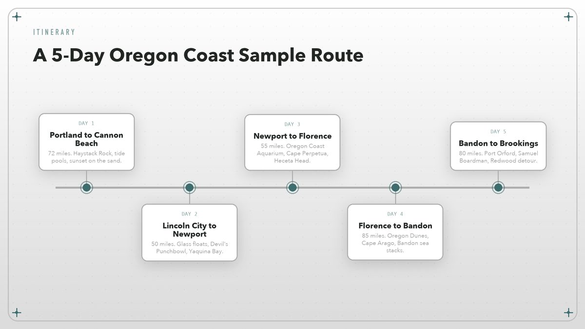
Day one takes you from Portland to Cannon Beach, about seventy miles. Stop at the Oregon State Parks visitor center at Fort Stevens on your way out if you want a quick history lesson, then head down to Cannon Beach for the evening. Walk the beach at sunset, when Haystack Rock turns gold and the crowds thin.
Day two runs from Cannon Beach to Newport, roughly fifty miles if you stay on the highway, though you will not. Take the side road through Tillamook for cheese or ice cream, loop out to Cape Meares for the lighthouse, and cut back to the coast at Oceanside. In Newport, spend the late afternoon on the bayfront and eat somewhere with a view of the working harbor.
Day three goes from Newport to Florence, about fifty-five miles. This is the lighthouse day. Yaquina Head Outstanding Natural Area has a lighthouse and a cobble beach full of harbor seals. Cape Perpetua, just south of Yachats, has the famous Thor’s Well, a saltwater blowhole that drains and refills with each wave. Do not get too close. People have died trying for the perfect photograph.
Day four is Florence to Bandon, the longest driving day at about eighty-five miles. The Oregon Dunes are the obvious morning stop. After that, the stretch between Florence and Coos Bay is less dramatic, so push through and save your time for Cape Arago and the sea stacks at Bandon. End the day with fish and chips on the waterfront.
Day five carries you from Bandon to Brookings, another eighty miles. This is the wildest section. Port Orford’s dock, the viewpoints along Samuel H. Boardman, and the final descent into Brookings make for a slow, rewarding day. From Brookings, cut inland on U.S. 199 toward Grants Pass, or cross into California and continue south on Highway 101.
Where to Sleep Inns, motels, yurts, and campsites
The Oregon Coast has every kind of lodging, from chain motels in Lincoln City to historic inns in Astoria to yurts in state parks. The yurts are the sweet spot for many travelers. They are heated, furnished with beds and lights, and located in some of the most beautiful campgrounds on the coast. You still need to bring bedding or rent it, and you still share a communal bathroom, but you avoid the hassle of pitching a tent in wind and sand.
Small inns in Cannon Beach, Manzanita, and Newport offer more comfort and often better locations. Prices are highest in summer and on weekends. If you are flexible, midweek stays save money and reduce the sense of fighting through crowds.
Camping is the classic choice. State park campgrounds like Nehalem Bay, Beverly Beach, Sunset Bay, and Harris Beach take reservations through the Oregon State Parks system. Some first-come, first-served sites exist, but do not depend on them in July. Beach camping in the dunes is also possible through the Siuslaw National Forest, though restrictions apply and you should check current rules.
Airbnb and vacation rentals are widely available, but they have changed the character of some coastal towns. They are useful for groups or longer stays. For a short road trip, I prefer a motel or a yurt. You spend so little time in the room anyway.
What to Eat Chowder, fish, and coastal beer
The food on the Oregon Coast is not fancy. It is local, which is better. Seafood comes off the boats in Newport, Coos Bay, and Port Orford. Dungeness crab, razor clams, rockfish, and salmon appear on menus up and down the highway. Clam chowder is the unofficial regional dish, served in bread bowls at nearly every waterfront restaurant.
Each town has its own claims. Tillamook is synonymous with cheese and ice cream. Newport has a cluster of fish houses on the bayfront. Bandon has cranberries growing in bogs just inland, and you will find cranberry sauces, jellies, and even cranberry beer. Brookings has a surprising number of good sushi spots thanks to its commercial fishing fleet.
Craft beer is everywhere. Oregon’s brewing culture did not stop at the Coast Range. Most towns have at least one brewery, and many are worth a stop. Pelican Brewing in Pacific City and Buoy Beer in Astoria are two of the bigger names, but smaller operations in Newport, Florence, and Bandon hold their own.
Bring a cooler. Grocery stores are scattered but not always convenient, and a roadside picnic on a foggy headland beats most restaurant dining rooms. Buy cheese in Tillamook, smoked fish in Garibaldi, bread in Manzanita, and fruit at a farm stand inland.
Practical Details That Matter Driving, safety, and etiquette
Highway 101 is generally well maintained, but it is also a coastal road. Landslides happen, especially after winter storms, and the Oregon Department of Transportation posts current road conditions on its TripCheck site. Always check conditions before setting out in winter or early spring.
Beach driving is restricted. In Oregon, the beaches are public highways in some places, meaning vehicles can drive on certain stretches. Do not assume this is allowed everywhere. Look for signs, and never drive on the sand near nesting shorebirds or harbor seals.
Tide pools require care. Walk on bare rock or sand, not on the animals. Do not pry sea stars off rocks or turn over large rocks. The rule is simple: look, do not take. Many tide-pool areas are protected, and rangers do enforce the rules.
Dogs are allowed on most Oregon beaches if leashed, though rules vary by town and season. State parks generally require leashes. If you are traveling with a dog, check the specific beach regulations before letting them run.
Leave no trace sounds like a slogan, but on the coast it is a necessity. Pack out everything, including biodegradable scraps. The wind will carry an apple core farther than you think, and the gulls do not need the encouragement.
The best Oregon Coast trip is not the one where you see everything. It is the one where you stop caring about the checklist and start noticing the light.
How to Use This Guide Make it your own
This is a framework, not a script. If you only have a weekend, pick one stretch and explore it thoroughly. Cannon Beach and Ecola State Park will keep a northern-coast weekend full. A central-coast weekend could center on Newport, the aquarium, and the dunes. A southern weekend could be nothing but Bandon and the Samuel H. Boardman corridor.
If you have two weeks, add side trips. Head inland from Florence to the Umpqua Valley wine country. Cut east from Newport to the Willamette Valley. From Astoria, cross the Columbia River into Washington and explore the Long Beach Peninsula. The coast is the anchor, but the region around it is worth the detour.
For tide predictions that shape beach walks and tide-pool visits, NOAA’s Tides and Currents website is the most reliable source. Pair it with the Oregon State Parks site for park closures and seasonal highlights. Use both to fill in the gaps this guide cannot cover, because the coast changes with the weather and the tide.
Whatever version of the trip you choose, bring a jacket. The ocean is cold, the wind is real, and the people who look comfortable are the ones who packed layers. That is the oldest Oregon Coast advice there is, and it still holds up.
External sources: Oregon State Parks, National Park Service Lewis and Clark, Federal Highway Administration Oregon Byways, Recreation.gov Oregon Dunes, and NOAA Tides and Currents.